(Click on your choice below or on the map.)
Richmond Fen from the North - 2
Dobson Lane - 3
Goodstown Road - 4
Harbison Road - 5
Proven Line Road - 6
Paauw Road - 7
Klondike Road West - 8
Pierce Road West - 9
Gallagher Road - 10
NW of Harnett Road - 11
SW of Mulholland Road - 12
Harnett Road - 13
Weedmark Road - 14
Paden Road Trails - 15
Brassils Creek at Paden Road - 16
SW of Paden Road - 17
Dwyer Hill Road Marsh - 18
Heaphy Road - Rideau Trail - 19
Flood Road - 20
Trail 25-5 on Dwyer Hill Road - 21
Trail 21-6 on Roger Stevens Drive - 22
Trail 18-5 on Roger Stevens Drive - 23
Cedar Grove Nature Trail - 24
Trail 13-6 on Roger Stevens Drive - 25
Pine Trail on Dwyer Hill Road - 26
William Campbell Road - 27
Montague Boundary Road - 28
Old Rideau Trail on Dwyer Hill Road - 29
Nichols Creek at Dwyer Hill Road - 30
O'Neil Road - 31
NE of Purdy Road - 32
Munster Road and Soldier's Line - 33
Munster and Kettles Roads - 34
Ruffed Grouse Area on Kettles Road - 35
Richmond Fen via Kettles Road - 36
Munster Sewage Lagoons - 37
Bleeks Road - 38
Conley Road - 39
Richmond Fen via Joy's Road (Canoe) - 40
Return to Birding Ottawa Table of Contents.
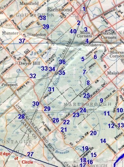
The Marlborough Forest is the centerpiece of this loop route. Within the forest's area are myriad trails and old unmaintained roadways, providing wonderful access to this huge natural tract. Much of the land is owned by the crown, though it is mixed in places with private land. There are several provincially significant wetlands in the forest: the Brassils Creek Wetland, the Steven Creek Wetland and the Richmond Fen Wetland. The latter is the home of the Ottawa area's only known Yellow Rail colony. The Rideau Trail has a 16 km segment through the forest. Snowmobilers and skiers keep several other trails open.
The loop has other attractions, as well. The Munster Sewage Lagoons and the old Richmond Lagoons provide shorebird, waterfowl and marsh habitat. While the Bleeks Road, Conley Road and Gallagher Road sites offer excellent owling.
The star site of this loop route is the Richmond Fen. It can be reached three ways, Richmond Fen from the North, via Kettles Road and via Joy's Road (canoe only). The marshes at Munster Road & Soldier's Line and Munster & Kettles Roads have been very productive over the years.