O'NEIL ROAD
Spring: ** Summer: ** Fall: ** Winter:**
Independent Directions to this Site: From Highway 417 (The Queensway) take exit 145 (Highway # 7). If driving east, a 0.8 km offramp brings you to right or southeast, then south, onto Highway # 7. If travelling west, the offramp to the right brings you southwest, then south, 1.4 km to meet the eastbound traffic on Highway # 7. From here, both groups will now follow Highway # 7 south, then southwest, 10.9 km to Regional Road 3 or the Dwyer Hill Road. Turn left or southeast onto Dwyer Hill and follow it 17.5 km to O'Neil Road. Turn left or northeast onto O'Neil and drive 1.7 km to the end of the gravel portion of the road, opposite number 4208 O'Neil. There is a small parking area here for the trails to the northeast on the forestry road portion of O'Neil Road.
Marlborough Forest Loop Route Directions: From the bridge over Nichols Creek at Dwyer Hill Road, go northwest on Dwyer Hill 0.4 km to O'Neil Road. Turn right or northeast onto O'Neil and drive 1.7 km to the end of the gravel portion of the road, opposite number 4208 O'Neil. There is a small parking area here for the trails to the northeast on the forestry road portion of O'Neil Road.
 Map of the O'Neil Road Area
Click on other site numbers to go to their pages.
Map of the O'Neil Road Area
Click on other site numbers to go to their pages.
Site Description and Birding Information: The gravel road into the parking area passes through woodland, the railway and power line rights-of-way and a wooded swamp with snags (the kind favoured by Olive-sided Flycatcher - which has been seen within a few kilometres of here in the past). The roadway beyond house 4208 is a forest access road and is gated and closed to vehicles Apr. 1 to Sept. 15, because of the danger of fire. It runs through mixed second growth and crosses a trail going left shortly after the gate. After a half kilometre it bears right and after 1.6 km encounters the Old Rideau Trail on Dwyer Hill Road track.
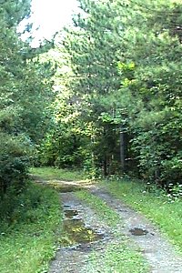 Forest Access Portion of O'Neil Road
Marlborough Forest Loop Route Directions: From the parking area opposite number 4208 O'Neil Road, return the 1.7 km to Dwyer Hill Road. Turn right or northwest on Dwyer Hill and proceed 3.5 km to Purdy Road. Park on the right or northeast of the east end of Purdy Road. This is the access point for the next site on this loop, the track NE of Purdy Road.
Return to Marlborough Forest Loop
Return to Birding Ottawa Table of Contents
|