CONLEY ROAD
Spring: *** Summer: ** Fall: * Winter:*
Independent Directions to this Site: From Highway 416 take exit 66 (Fallowfield Road). If southbound, a 0.4 km offramp dumps onto Fallowfield, where you will turn right or west. If northbound, the 0.4 km offramp brings you to Fallowfield, where you will turn left or west onto it and in 0.5 km join the southbound offramp traffic. Both groups will now follow Fallowfield Road west 13.4 km to reach Conley Road. Turn left or southeast onto Conley Road and drive 2.9 km to Bleeks Road. Continue straight or southeast on Conley Road.
Marlborough Forest Loop Route Directions: From the deadend of Bleeks Road, return the kilometre or so to Conley Road. Turn left or southeast onto Conley Road.
 Map of the Conley Road Area
Site Description and Birding Information: In early spring, say March and April, many birders indulge in noctural hunts for owls. This 2.4 km stretch of Conley Road is one of the favourite local spots for this. Great Horned, Barred and Eastern Screech Owls have all been found, or at least heard, along this road. Stop along the road every so often to listen, especially in those areas marked on the map above. One area of particular interest is the stream crossing, which, on the northeast side of the road, opens into a broad finger of marshland extending away to the northeast. This opening, with forest surrounding it, is an excellent listening post. Some marsh birds occur as well.
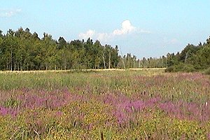 View of Marsh along Conley Road
Another excellent spot for owling is the area near the junction of Conley with Copeland Road. It is well wooded on all sides and several stops may be worthwhile, including a couple on the northeastern end of Copeland.
Just 2 to 3 km northwest of Bleeks Road, between Mansfield and Fallowfield Roads, check the farmlands along Conley Road for Upland Sandpiper.
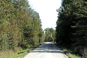 View of Conley Road near Copeland Road
Marlborough Forest Loop Route Directions: From wherever you are on Conley Road, continue southeast to Franktown Road (0.2 km beyond where the trees end). Turn left or northeast on Franktown and drive 3.1 km to Joy's Road (formerly Joy's Side Road). Turn right or southeast onto it and go 1.4 km to Ottawa Street, then turn right or southwest on Ottawa and proceed 0.1 km to where Joy's Road continues to the left or southeast. Take Joy's Road 0.9 km, past the golf course, to as close as you can get to the Jock River. Beyond the golf club the road deteriorates and the last 100 metres may be impassable, especially after a rain. The river access here, such as it is, is the last site on this loop, the Richmond Fen via Joy's Road canoe-only access route.
Return to Marlborough Forest Loop
Return to Birding Ottawa Table of Contents
|