FLOOD ROAD
Spring: ** Summer: ** Fall: ** Winter:**
Independent Directions to this Site: From Highway 416 take exit 49 (Roger Stevens Drive). If southbound, a 0.4 km offramp dumps onto Bankfield, where you will turn right or southwest. If northbound, the 0.4 km offramp brings you to Bankfield, where you will turn left or southwest onto it and in 0.4 km join the southbound offramp traffic. Both groups will now follow Roger Stevens Drive southwest 18.6 km to the Dywer Hill Road. Turn left or southeast on Dywer Hill Road and proceed 4.0 km to Flood Road. Turn left or northeast into Flood Road.
Marlborough Forest Loop Route Directions: From where the Heaphy Road - Rideau Trail track crosses the Dwyer Hill Road, continue northwest on Dwyer Hill Road for 1.5 km to Flood Road. Turn right or northeast into Flood Road.
 Map of the Flood Road Area
Site Description and Birding Information: The first few good gravel kilometres of Flood Road take one northeast through a variety of habitat. A new bridge crosses Brassils Creek at 0.6 km, providing views of the riparian area. Beyond the bridge are some old fields (potential shrike habitat), then a few farms, and finally the road becomes a rough unmaintained roadway beyond 4174 Flood. The track continues as a trail which eventually crosses the Rideau Trail about 3.2 km from Dwyer Hill Road.
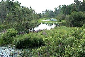 Brassils Creek Croosing Flood Road
Marlborough Forest Loop Route Directions: From wherever you are on Flood Road, return southwest to Dwyer Hill Road. Turn right or northwest on Dwyer Hill Road for 2.6 km to the pulloff for the trailhead (marked by a "25-5" sign) of the next site in the loop, Trail 25-5 on Dwyer Hill Road.
Return to Marlborough Forest Loop
Return to Birding Ottawa Table of Contents
|