BRASSILS CREEK AT PADEN ROAD
Spring: ** Summer: ** Fall: ** Winter:*
Independent Directions to this Site: From Highway 416 take exit 49 (Roger Stevens Drive). If southbound, a 0.4 km offramp dumps onto Bankfield, where you will turn right or southwest. If northbound, the 0.4 km offramp brings you to Bankfield, where you will turn left or southwest onto it and in 0.4 km join the southbound offramp traffic. Both groups will now follow Roger Stevens Drive southwest 8.2 km to Malakoff Road. Turn left or southeast onto Malakoff Road and go 1.7 km to Gallagher Road. Turn right or south onto Gallagher Road and proceed 4.4 km to its junction with Harnett Road. Turn left or southeast and drive 2.6 km to Paden Road. Turn right or southwest onto Paden and drive 6.5 km to the bridge on Paden Road over Brassils Creek.
Marlborough Forest Loop Route Directions: From the first wood road heading northwest into the Paden Road Trails area, continue southwest for 1.2 km to the bridge on Paden Road over Brassils Creek.
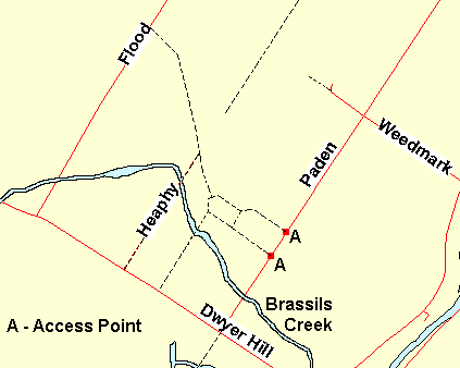 Map of the Paden Road Area
Site Description and Birding Information: Brassils Creek crosses Paden Road here, providing excellent views of this riparian habitat. Some penetration of this wetland may be possible by canoe from here.
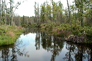 Brassils Creek at Paden Road
Marlborough Forest Loop Route Directions: From the crossing of Brassils Creek at Paden Road, continue southwest 0.7 km on Paden to the Dywer Hill Road. Cross Dywer Hill Road and park on the other side of it at the entrance to the next site in this loop, the track extending SW of Paden Road.
Return to Marlborough Forest Loop
Return to Birding Ottawa Table of Contents
|