WILLIAM CAMPBELL ROAD
Spring: ** Summer: *** Fall: ** Winter:**
Independent Directions to this Site: From Highway 416 take exit 49 (Roger Stevens Drive). If southbound, a 0.4 km offramp dumps onto Bankfield, where you will turn right or southwest. If northbound, the 0.4 km offramp brings you to Bankfield, where you will turn left or southwest onto it and in 0.4 km join the southbound offramp traffic. Both groups will now follow Roger Stevens Drive southwest 21.2 km (crossing Dywer Hill Road at 18.6 km) to the turnoff to the right or straight to the Montague Boundary Road, while Roger Stevens bears left. Take the connector 150 metres to Montague Boundary Road and turn right or northwest onto the Montague Boundary Road and drive 0.2 km to William Campbell Road. Turn left or southwest onto it and enter the William Campbell Road.
Marlborough Forest Loop Route Directions: From the pulloff for the Pine Trail on Dwyer Hill Road, return southeast on Dwyer Hill Road the 0.7 km to Roger Stevens Drive. Turn right or southwest onto it and drive 2.6 km to the turnoff to the right or straight to the Montague Boundary Road in 150 metres, while Roger Stevens bears left. Turn right or northwest onto the Montague Boundary Road and drive 0.2 km to William Campbell Road. Turn left or southwest onto it and enter the William Campbell Road.
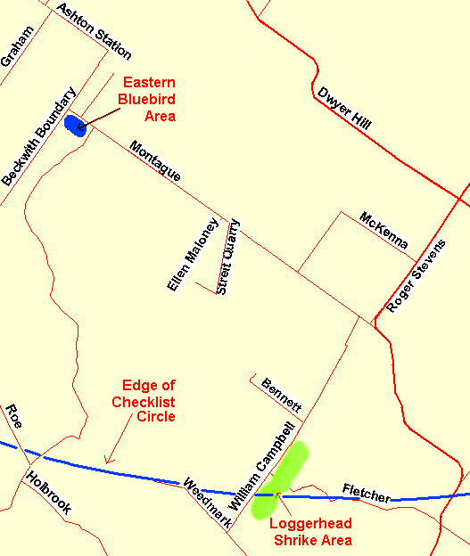 Map of the William Campbell Road Area
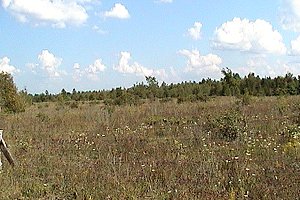
Site Description and Birding Information: This good gravel road is at the southwestern edge of the Ottawa Checklist Circle. In fact, the road passes out of the circle near # 761 Campbell Road, where the old church lies just outside. The first kilometre of the road goes through hay fields; the second through second growth woodland to Bennett Road. From Bennett Road to the end of Campbell Road, beyond the edge of the circle, is the area of greatest interest at the site. These 2.4 kilometres (only the first kilometre of which is actually inside the circle) consist of overgrown, weedy fields with scattered bushes and occasional fencelines. Loggerhead Shrike has bred here regularly for over a decade now, but is often hard to find. They have been seen mostly on the south side of Campbell Road, between numbers 761 (the old church) and 826 (all outside the circle's boundary). Watch for movement and scan the field edges and bushes, preferably with a scope. Don't ignore the rest of the area, as shrikes move their nests each year.
Field and scrub loving species such as Common Snipe, Gray Catbird, Brown Thrasher, Vesper Sparrow, Eastern Meadowlark and Bobolink bred here. Upland Sandpiper also bred here, easiest to find in late May and June. Other scarcities found in this area are: Whimbrel (20 on Aug. 5, 1990), Northern Mockingbird (Aug. 5, 1990).
 William Campbell Road
Marlborough Forest Loop Route Directions: From wherever you are on the William Campbell Road, return northeast the Montague Boundary Road. Turn left or northwest onto the Montague Boundary Road and enter the next site in our loop, the Montague Boundary Road.
Return to Marlborough Forest Loop
Return to Birding Ottawa Table of Contents
|