HEAPHY ROAD - RIDEAU TRAIL
Spring: ** Summer: ** Fall: ** Winter:**
Independent Directions to this Site: From Highway 416 take exit 49 (Roger Stevens Drive). If southbound, a 0.4 km offramp dumps onto Bankfield, where you will turn right or southwest. If northbound, the 0.4 km offramp brings you to Bankfield, where you will turn left or southwest onto it and in 0.4 km join the southbound offramp traffic. Both groups will now follow Roger Stevens Drive southwest 18.6 km to the Dywer Hill Road. Turn left or southeast on Dywer Hill Road and proceed 5.5 km to where the Rideau Trail crosses it at what used to be Heaphy Road.
Marlborough Forest Loop Route Directions: From the Dwyer Hill Road Marsh, continue straight or northwest on Dwyer Hill Road for 1.0 km to where the Rideau Trail crosses Dwyer Hill Road at what used to be Heaphy Road.
 Map of the Heaphy Road - Rideau Trail Area
Site Description and Birding Information: The famous Rideau Trail passes here. From this point, one can go either southwest or northeast. The southwestern track, after about 3km, crosses the SW of Paden Road track. But the northeastern direction is the route recommended for best birding. The sign at Dwyer Hill Road states "Roger Stevens Drive - 9.5 km". This would be at the Cedar Grove Nature Trail site. This unmaintained roadway is probably left undriven, unless you have high clearance. After about 0.8 km of second growth, the first of the Brassils Creek Wetland area is reached. Here is a beautiful patch of marsh and swamp, where you may find Virginia Rail, Common Gallinule, Black Tern and all the regular marsh birds of our area. The trail continues over a hill of maturing deciduous, and down to Brassils Creek itself about 1.4 km in. Beyond the creek, the trail rises again into abandonned farmland.
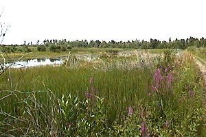
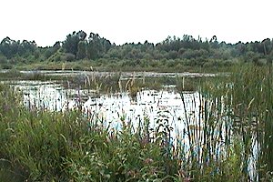 Brassils Creek Wetland on the Heaphy Road Section of the Rideau Trail
Marlborough Forest Loop Route Directions: From where the Rideau Trail, a.k.a. Heaphy Road crosses the Dwyer Hill Road, continue straight or northwest on Dwyer Hill Road for 1.5 km to Flood Road. Turn right or northeast into the next site in the loop, Flood Road.
Return to Marlborough Forest Loop
Return to Birding Ottawa Table of Contents
|