TRAIL 21-6 ON ROGER STEVENS DRIVE
Spring: ** Summer: ** Fall: ** Winter:**
Independent Directions to this Site: From Highway 416 take exit 49 (Roger Stevens Drive). If southbound, a 0.4 km offramp dumps onto Bankfield, where you will turn right or southwest. If northbound, the 0.4 km offramp brings you to Bankfield, where you will turn left or southwest onto it and in 0.4 km join the southbound offramp traffic. Both groups will now follow Roger Stevens Drive southwest 16.9 km to the pulloff to the left or southeast for the trailhead (marked by a "21-6" sign) of Trail 21-6 on Roger Stevens Drive.
Marlborough Forest Loop Route Directions: From the pulloff for the trailhead of Trail 25-5 on Dwyer Hill Road, turn right or northwest onto Dwyer Hill Road. Proceed 1.4 km to Roger Stevens Drive and turn right or northeast onto it. Drive 1.7 km to the pulloff to the right or southeast for the trailhead (marked by a "21-6" sign) of Trail 21-6 on Roger Stevens Drive.
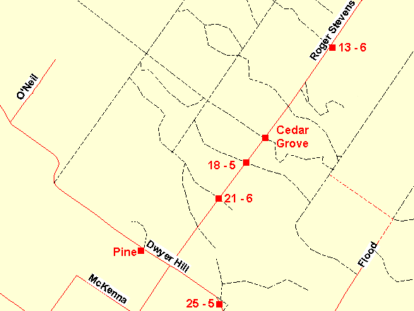 Map of the Trail 21-6 on Roger Stevens Drive Area
Site Description and Birding Information: This trail is an actual forestry road, closed to vehicles from April 1 to September 15 due to fire risk.
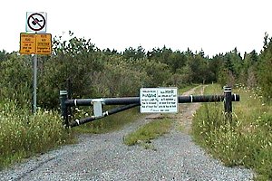 Trail 21-6 on Roger Stevens Drive
Marlborough Forest Loop Route Directions: From the pulloff for the trailhead of Trail 21-6 on Roger Stevens Drive, turn right or northeast onto Roger Stevens Drive. Drive 1.4 km to the pulloff to the right or southeast for the trailhead (marked by a "18-5" sign) of the next site in the loop, Trail 18-5 on Roger Stevens Drive.
Return to Marlborough Forest Loop
Return to Birding Ottawa Table of Contents
|