HARBISON ROAD
Spring: ** Summer: ** Fall: ** Winter:*
Independent Directions to this Site: From Highway 416 take exit 57 (Bankfield Road). If southbound, a 0.4 km offramp dumps onto Bankfield, where you will turn right or southwest. If northbound, the 0.4 km offramp brings you to Bankfield, where you will turn left or southwest onto it and in 0.4 km join the southbound offramp traffic. Both groups will now follow Bankfield Road southwest 6.8 km to Eagleson Road. Turn left or southeast onto Eagleson Road and drive 2.2 km to Century Road. Turn right or southwest onto it (beware the triangular junction) and go 0.6 km to Malakoff Road. Turn left or southeast onto it and drive 1.6 km to Harbison Road. Turn right or southwest onto it and proceed 3.8 km to the end of the maintained roadway at 3186 Harbison. The unmaintained portion of Harbison Road lies beyond here.
Marlborough Forest Loop Route Directions: From the southwest end of Goodstown Road, return northeast 1.4 km to McBean Street and Century Road. Continue straight northeast onto Century Road and go 0.3 km to Malakoff Road. Turn right or southeast onto it and drive 1.6 km to Harbison Road. Turn right or southwest onto it and proceed 3.8 km to the end of the maintained roadway at 3186 Harbison. The unmaintained portion of Harbison Road lies beyond here.
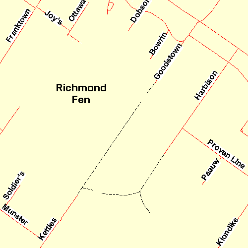 Map of the Harbison Road Area
Site Description and Birding Information: Harbison Road is a good gravel road which passes agricultural land until it reaches Proven Line Road, after which it dips downward to pass a sizable cattail swamp (worth checking), before the end of the maintained roadway at # 3186. There you will see the "Unmaintained Roadway - Use at Own Risk" sign.
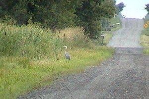 Great Blue Heron at the Marsh along Harbison Road
Beyond the road's end, there is an old roadbed leading farther southwest. Rubber boots (maybe even hip-waders sometimes) are needed here, except when frozen in winter. The trail crosses open marsh, overgrown cattail swamp and black spruce swamp habitats. After about 1.6 km, the track branches to both the right or west and to the left or southeast.
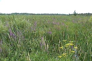 View from Trail SW of Harbison Road
Marlborough Forest Loop Route Directions: From the southwest end of Harbison Road, return northeast 1.1 km to Proven Line Road. Turn right or southeast onto the next site in this loop, Proven Line Road.
Return to Marlborough Forest Loop
Return to Birding Ottawa Table of Contents
|