HARNETT ROAD
Spring: ** Summer: ** Fall: ** Winter:**
Independent Directions to this Site: From Highway 416 take exit 49 (Roger Stevens Drive). If southbound, a 0.4 km offramp dumps onto Bankfield, where you will turn right or southwest. If northbound, the 0.4 km offramp brings you to Bankfield, where you will turn left or southwest onto it and in 0.4 km join the southbound offramp traffic. Both groups will now follow Roger Stevens Drive southwest 8.2 km to Malakoff Road. Turn left or southeast onto Malakoff Road and go 1.7 km to Gallagher Road. Turn right or south onto Gallagher Road and proceed 4.4 km to its junction with Harnett Road. Turn left or southeast and drive 0.9 km to Mulholland Road. Continue straight or southeast on Harnett Road into the area between Mulholland and Paden Roads.
Marlborough Forest Loop Route Directions: From where you are parked just on Harnett Road near the extension SW of Mulholland Road, continue straight or southeast on Harnett Road into the area between Mulholland and Paden Roads.
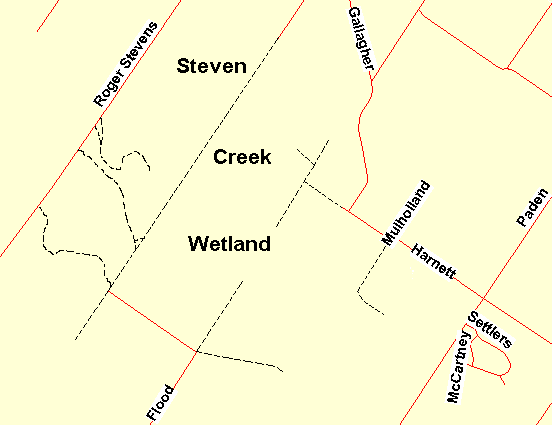 Map of the Harnett Road Area
Site Description and Birding Information: This section of Harnett Road goes through an excellent variety of habitats, including a large cattail marsh just south of Mulholland Road, cedar woods, abandoned fields (possible shrike area), and mixed woods. Good owling potential too.
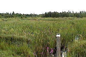 View of the Marsh on Harnett Road
Marlborough Forest Loop Route Directions: From wherever you are on Harnett Road, continue straight southeast to Paden Road. Turn right or southwest onto Paden and drive 3.3 km to Weedmark Road. Turn right or northwest onto it and go 0.7 km to its end at 7435 Weedmark. This is the next site in this loop, the area Weedmark Road.
Return to Marlborough Forest Loop
Return to Birding Ottawa Table of Contents
|