PAAUW ROAD
Spring: ** Summer: ** Fall: ** Winter:**
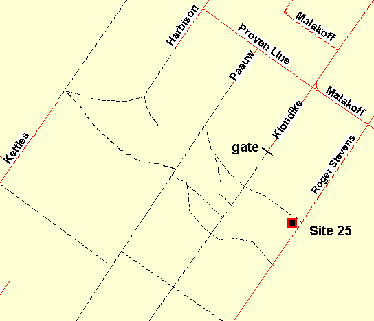
Independent Directions to this Site: From Highway 416 take exit 57 (Bankfield Road). If southbound, a 0.4 km offramp dumps onto Bankfield, where you will turn right or southwest. If northbound, the 0.4 km offramp brings you to Bankfield, where you will turn left or southwest onto it and in 0.4 km join the southbound offramp traffic. Both groups will now follow Bankfield Road southwest 6.8 km to Eagleson Road. Turn left or southeast onto Eagleson Road and drive 2.2 km to Century Road. Turn right or southwest onto it (beware the triangular junction) and go 0.6 km to Malakoff Road. Turn left or southeast onto it and drive 1.6 km to Harbison Road. Turn right or southwest onto it and proceed 2.7 km Proven Line Road. Turn left or southeast onto Proven Line Road and go 1.6 km to Paauw Road. Turn right or southwest on it and go 0.6 km to end of the maintained roadway at 3115 Paauw. The unmaintained portion of Paauw Road lies beyond here.
Marlborough Forest Loop Route Directions: Having driven Proven Line Road the 1.6 km southeast to Paauw Road, turn right or southwest on it and go 0.6 km to end of the maintained roadway at 3115 Paauw. The unmaintained portion of Paauw Road lies beyond here.
 Map of the Paauw Road Area
Site Description and Birding Information: The extension of Paauw Road to the southwest of its maintained portion is kept open by snowmobilers in winter and 4-wheelers in summer. The old roadbed extends into the Marlborough Forest possibly all the way through to the Old Rideau Trail on Dwyer Hill Road site. It goes through a good variety of habitats, from relatively open overgrown farmland, through second growth mixed woodland, through cedar woods and passes short stretches of swampland on occasion. Should be good for owling.
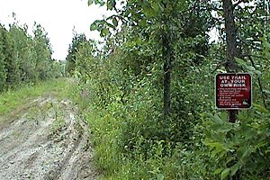
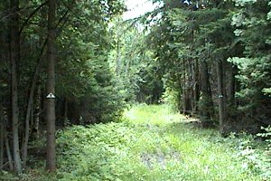 Views of the Paauw Road Extension
Marlborough Forest Loop Route Directions: From the southwest end of Paauw Road, return northeast 0.6 km to Proven Line Road. Turn right or southeast onto it and go 1.6 km to Klondike Road. Turn right or southwest and proceed 2.4 km to end of the maintained roadway at 3378 Klondike. The next site in this loop is the unmaintained portion of Klondike Road West beyond here.
Return to Marlborough Forest Loop
Return to Birding Ottawa Table of Contents
|