PADEN ROAD TRAILS
Spring: ** Summer: ** Fall: ** Winter:**
Independent Directions to this Site: From Highway 416 take exit 49 (Roger Stevens Drive). If southbound, a 0.4 km offramp dumps onto Bankfield, where you will turn right or southwest. If northbound, the 0.4 km offramp brings you to Bankfield, where you will turn left or southwest onto it and in 0.4 km join the southbound offramp traffic. Both groups will now follow Roger Stevens Drive southwest 8.2 km to Malakoff Road. Turn left or southeast onto Malakoff Road and go 1.7 km to Gallagher Road. Turn right or south onto Gallagher Road and proceed 4.4 km to its junction with Harnett Road. Turn left or southeast and drive 2.6 km to Paden Road. Turn right or southwest onto Paden and drive 5.3 km to a woods road leading off to the right or northwest. This is the entry to the Paden Road Trails site.
Marlborough Forest Loop Route Directions: From the northwest end of Weedmark Road, return southeast the 0.7 km to Paden Road. Turn right or southwest and drive 2.0 km to a woods road leading off to the right or northwest. This is the entry to the Paden Road Trails site.
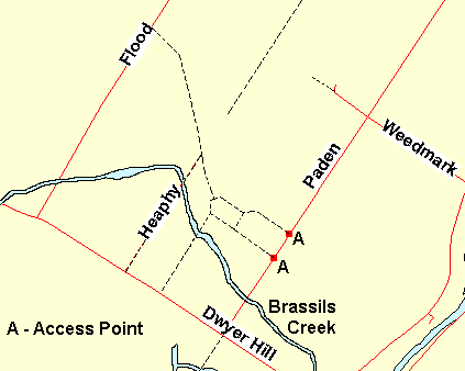 Map of the Paden Road Trails Area
Site Description and Birding Information: This wood road, and another 0.4 km farther southwest on Paden Road, are twin entry points into this area. These roads may be passable for 4WD's or dirt bikes, but are best walked. These trails go through the upland area just east of the Brassils Creek Wetland. Much of this area consists of abandonned farmland and second growth. Beware: there is an old gravel pit that is used as a shooting range. About 1.3 km northwest of Paden Road, a trail going left or southwest leads directly into that wetland.
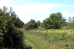
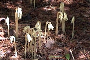 Views along the Paden Road Trails
Marlborough Forest Loop Route Directions: From the first wood road heading northwest into the Paden Road Trails area, continue southwest for 1.2 km to the bridge on Paden Road over Brassils Creek. This is the next site in this loop, the Brassils Creek at Paden Road.
Return to Marlborough Forest Loop
Return to Birding Ottawa Table of Contents
|