NE OF PURDY ROAD
Spring: ** Summer: ** Fall: ** Winter:**
Independent Directions to this Site: From Highway 417 (The Queensway) take exit 145 (Highway # 7). If driving east, a 0.8 km offramp brings you to right or southeast, then south, onto Highway # 7. If travelling west, the offramp to the right brings you southwest, then south, 1.4 km to meet the eastbound traffic on Highway # 7. From here, both groups will now follow Highway # 7 south, then southwest, 10.9 km to Regional Road 3 or the Dwyer Hill Road. Turn left or southeast onto Dwyer Hill and follow it 14.0 km to Purdy Road. Park on the left or northeast of the east end of Purdy Road. This is the access point for the track NE of Purdy Road.
Marlborough Forest Loop Route Directions: From the parking area on O'Neil Road, opposite number 4208, return the 1.7 km to Dwyer Hill Road. Turn right or northwest on Dwyer Hill and proceed 3.5 km to Purdy Road. Park on the right or northeast of the east end of Purdy Road. This is the access point for the track NE of Purdy Road.
 Map of the NE of Purdy Road Area
Click on other site numbers to go to their pages.
Map of the NE of Purdy Road Area
Click on other site numbers to go to their pages.
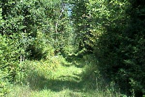 The Track NE of Purdy Road
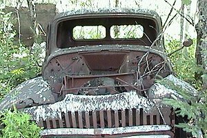
Site Description and Birding Information: This track is actually an Unopen Road Allowance that continues 3 km to Munster Road and Soldier's Line. It travels through overgrown, abandonned farmland for about 1.3 km; then just beyond the rusting truck and old foundation, it begins to pass through wet, marshy areas. Here you will find the major snowmobile trail junction, where you can choose an alternate direction.
 Along the Track NE of Purdy Road
Marlborough Forest Loop Route Directions: From the junction of Purdy and Dwyer Hill Roads, go northwest on Dwyer Hill 1.6 km to the Jock Trail. Turn right or northeast onto the Jock Trail and proceed 3.0 km to Munster Road. Turn right or southeast onto it and drive 1.6 km to the next site on this loop, the Munster Road and Soldier's Line area.
Return to Marlborough Forest Loop
Return to Birding Ottawa Table of Contents
|