DWYER HILL ROAD MARSH
Spring: ** Summer: ** Fall: ** Winter:*
Independent Directions to this Site: From Highway 416 take exit 49 (Roger Stevens Drive). If southbound, a 0.4 km offramp dumps onto Bankfield, where you will turn right or southwest. If northbound, the 0.4 km offramp brings you to Bankfield, where you will turn left or southwest onto it and in 0.4 km join the southbound offramp traffic. Both groups will now follow Roger Stevens Drive southwest 18.6 km to the Dywer Hill Road. Turn left or southeast on Dywer Hill Road for 6.6 km to a large open marshy area. Park on the side of the road where you can get well off and scan this Dwyer Hill Road Marsh.
Marlborough Forest Loop Route Directions: From the track extending SW of Paden Road from Dwyer Hill Road, proceed left or northwest on Dwyer Hill Road for 0.6 km to a large open marshy area. Park on the side of the road where you can get well off and scan this Dwyer Hill Road Marsh.
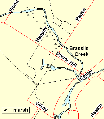 Map of the Dwyer Hill Road Marsh Area
Site Description and Birding Information: This large roadside marsh is worth scanning from the roadside. It has lots of standing dead trees around the edges, possible Olive-sided Flycatcher habitat, and sightings in the past not far away - you never know. Listen at dusk and after dark for marsh birds and owls.
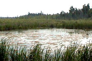 View of the Dwyer Hill Road Marsh
Marlborough Forest Loop Route Directions: From the Dwyer Hill Road Marsh, continue straight or northwest on Dwyer Hill Road for 1.0 km to to where the Rideau Trail crosses Dwyer Hill Road at what used to be Heaphy Road. This is the next site in the loop, Heaphy Road - Rideau Trail.
Return to Marlborough Forest Loop
Return to Birding Ottawa Table of Contents
|