(Click on your choice below or on the map.)
Tom Roberts Avenue - 2
Limebank Road - 3
Leitrim Road West - 4
Earl Armstrong Road - 5
High Road - 6
Leitrim Wetlands - 7
Leitrim Road East Trails- 8
Pine Grove Trails (Davidson Road) - 9
NCC Golf Course Trails - 10
Pine Grove Park (Conroy Pit) - 11
Alert Road - 12
Return to Southeast Routes.
Return to Birding Ottawa Table of Contents.
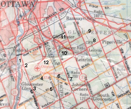
This loop explores the portion of Ottawa's "Greenbelt" that surrounds the International Airport. There are prime agricultural sites south of the airport, the best being Earl Armstrong Road and Limebank Road. The Leitrim Wetlands are a Class-1 Provincial Wetland. Excellent forested trails can be found at the Leitrim Road East Trails, the Pine Grove Trails (Davidson Road), and the NCC Golf Course Trails sites. The Airport Gravel Pit & Cottage Road, High Road, and Pine Grove Park (Conroy Pit) sites have good mixed habitat, with plenty of second-growth and scrub. And, of course, several sites are actually adjacent the airport itself; allowing study of that unique habitat that so resembles grassland to birds. Good viewing of airport lands can be had from the Tom Roberts Avenue, Leitrim Road West and Alert Road sites.