LEITRIM WETLANDS
Spring: ** Summer: ** Fall: ** Winter: **
Independent Directions to this Site: From Highway 417 (The Queensway) take exit 104 (Anderson Road). Go SSE on Anderson for 1.0 km to Leitrim Road. Turn right or southwest onto Leitrim and proceed 2.0 km to Ramseyville Road (previously Baseline Road). Turn left or SSE onto it and go 0.2 km to the continuation of Leitrim Road. Turn right or southwest onto it and drive 2.0 km to Hawthorne Road. Turn left or SSE onto Hawthorne and go 0.1 km to the next segment of Leitrim Road. Turn right or southwest onto it and travel 4.2 km to Albion Road. Turn left or SSE onto Albion and go c. 1.4 km and search for a place to pull off and park at the Letrim Wetlands.
Airport Loop Route Directions: From High Road, return to the junction of High and Earl Armstrong Roads and turn left or southeast onto the continuation of High Road. Go 1.0 km to Albion Road and turn left or NNW onto Albion Road. Travel about a kilometre and search for a place to pull off and park at the Letrim Wetlands.
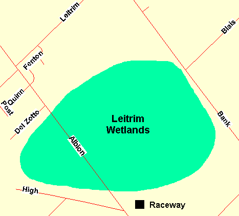 Map of Letrim Wetlands area
Site Description and Birding Information: This is the wetland with the heronry that is visible from the previous site, High Road. The Great Blue Herons that nest there return each spring in late March. This important wetland is threatened by developments - no surprise there. The remaining significant wetland areas may be made public land one day, but are currently owned by developers. There are no maintained trails, but the articles mentioned below suggest that non-destructive access may be allowed.
A seven hectare fen lies near the north end of this wetland. There are wet fields and willow scrub along the northern edge. There is a "flowage" area along the eastern side of the wetland. The central areas are predominantly larch and cedar, while the southern areas are predominantly hardwood (mostly red maple). Toward the south end is a stand of ancient cedars and hemlocks.
There are three excellent articles published in the Ottawa Field-Naturalists' Club's newsletter, Trail and Landscape, regarding this site. They are in the following issues: Vol. 24 - No. 2, Vol. 26 - No. 3, and Vol. 27 - No. 4. These writeups, by botanist Albert Dugal, detail the fight to try to preserve this Class 1 Provincial Wetland. The third article provides a list of 90 bird species seen there and suggests 150 to 160 species may be seen in a given year. Among the interesting species mentioned are Northern Goshawk, Virginia Rail, several species of owl, Yellow-billed Cuckoo, Willow Flycatcher, Sedge Wren, Golden-winged and Mourning Warbler, and Clay-colored Sparrow.
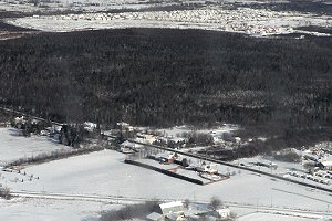 Letrim Wetlands from the Air - Note the Encroachment of 'Development' at the Top
Airport Loop Route Directions: From where you are parked to visit the Letrim Wetlands, continue NNW along Albion Road to its junction with Leitrim Road on the right or northeast, around 3 km from High Road. Turn right or northeast on Leitrim and follow it 4.2 km to Hawthorne Road. Turn left or NNW onto Hawthorne and go 0.1 km to the next segment of Leitrim Road. Turn right or northeast onto it and go 1.5 km to the parking lot, on the left or north side of the road, for the next site on this route, Leitrim Road East Trails.
Return to Airport Loop.
Return to Birding Ottawa Table of Contents.
|