TOM ROBERTS AVENUE
Spring: *** Summer: *** Fall: * Winter: *
Independent Directions to this Site: From Highway 417 (The Queensway) take exit 121A (Bronson Avenue). Go SSE on Bronson for 3.6 km, crossing the Rideau River on the Dunbar Bridge and going over Riverside Drive, before bearing right to take the Brookfield Road exit. In 0.1 km merge right onto Brookfield Road and drive 0.5 km to Riverside Drive. Turn left onto Riverside Drive and go 5.9 km to Limebank Road straight ahead. Continue straight SSE onto Limebank and drive 0.8 km to Tom Roberts Avenue. Turn left or ENE onto it.
Airport Loop Route Directions: From where you have parked at the Airport Gravel Pit & Cottage Road, return to Riverside Drive. Turn right or south on it and proceed 1.0 km to where it continues straight as Limebank Road (River Road veers to the left). Continue straight SSE onto Limebank and drive 0.8 km to Tom Roberts Avenue. Turn left or ENE onto it.
Site Description and Birding Information: The dead trees in the swamp at Limebank and Tom Roberts have hosted nesting Red-headed Woodpeckers in the past. They are good for other picids too. The road runs ENE 0.3 km to a gate accessing the new control tower for the Ottawa International Airport. Stop out of the way near the fence. Watch and listen for breeding Grasshopper Sparrows that can usually be found here, often perching on the fence wire. Vesper and Clay-coloured Sparrows are also found here.
Airport Loop Route Directions: From where you have parked on Tom Roberts Avenue, return to Limebank Road and turn left or SSE onto it. You are now on the next site on this route, Limebank Road.
Return to Airport Loop.
Return to Birding Ottawa Table of Contents.
|
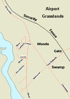 Map of Tom Roberts Avenue area
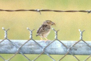 Grasshopper Sparrow on Airport Fence
|