LIMEBANK ROAD
Spring: *** Summer: ** Fall: ** Winter: ***
Independent Directions to this Site: From Highway 417 (The Queensway) take exit 121A (Bronson Avenue). Go SSE on Bronson for 3.6 km, crossing the Rideau River on the Dunbar Bridge and going over Riverside Drive, before bearing right to take the Brookfield Road exit. In 0.1 km merge right onto Brookfield Road and drive 0.5 km to Riverside Drive. Turn left onto Riverside Drive and go 5.9 km to Limebank Road straight ahead. Continue straight SSE onto Limebank and drive 0.8 km to Tom Roberts Avenue. Continue along Limebank Road.
Airport Loop Route Directions: From where you have parked on Tom Roberts Avenue, return to Limebank Road and turn left or SSE onto it.
Site Description and Birding Information: Beginning at the corner of Tom Roberts Avenue and Limebank Road, you will have the swamp mentioned in the previous site on your left. The dead trees there have hosted nesting Red-headed Woodpeckers in the past. They are good for other picids too.
On your right are farm fields or pasture which form the majority of habitat from here to Earl Armstrong Road on both sides of the road. These fields are good for Red-tailed and Rough-legged Hawks in winter as well as a good possibility of Snowy Owl most years. Upland Sandpiper should be watched for in spring and summer.
On the left, between the swamp and Leitrim Road, there is an extensive area of overgrown fields fenced off as part of the airport land. This scrubby area has produced Northern Shrike in winter. Another notable area, 3.9 km from Tom Roberts Avenue, is the ravine of Mosquito Creek. Wooded to the east and open with large trees (many dead ones) on the west, this spot has also had Red-headed Woodpecker in the past.
Gyrfalcon has been seen along this road in at least two different years. A Northern Hawk-Owl spent a couple months at Limebank and Rideau Road, c. 2 km SSE of Armstrong Road, in early 1988. A immature Golden Eagle was seen between Armstrong and Rideau Roads on Jan. 29, 1988.
Airport Loop Route Directions: From Limebank and Earl Armstrong Roads, return along Limebank Road 2.0 km to Leitrim Road. Turn right or ENE onto it. You are now on the next site on this route, Leitrim Road West.
Return to Airport Loop.
Return to Birding Ottawa Table of Contents.
|
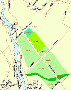 Map of Limebank Road area
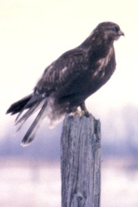 Dark-phase Rough-legged Hawk
|