LEITRIM ROAD EAST TRAILS
Spring: ** Summer: ** Fall: ** Winter: **
Independent Directions to this Site: From Highway 417 (The Queensway) take exit 104 (Anderson Road). Go SSE on Anderson for 1.0 km to Leitrim Road. Turn right or southwest onto Leitrim and proceed 0.7 km to the parking lot, on the left or north side of the road, for the Leitrim Road East Trails.
Airport Loop Route Directions: From where you are parked to visit the Letrim Wetlands, continue NNW along Albion Road to its junction with Leitrim Road on the right or northeast, around 3 km from High Road. Turn right or northeast on Leitrim and follow it 4.2 km to Hawthorne Road. Turn left or NNW onto Hawthorne and go 0.1 km to the next segment of Leitrim Road. Turn right or northeast onto it and go 1.5 km to the parking lot, on the left or north side of the road, for the Leitrim Road East Trails.
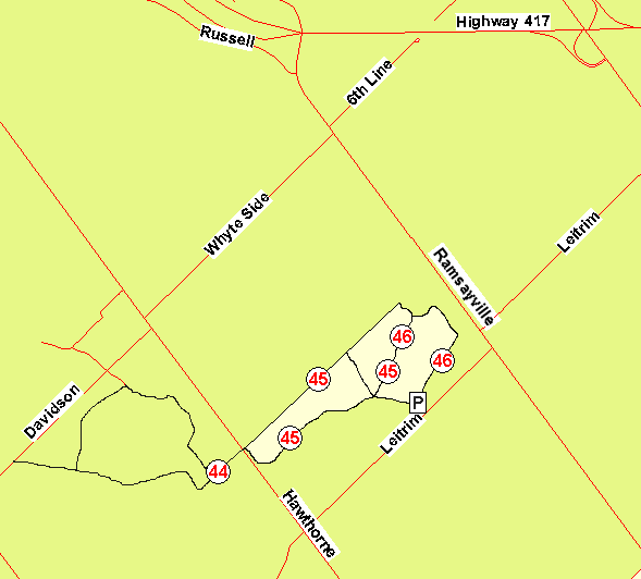 Map of Letrim Road East Trails
Site Description and Birding Information: This portion of the Pine Grove Forest Reserve section of the "Greeenbelt" has nearly 6 kilometres of trails enclosed by Leitrim, Hawthorne and Ramseyville (Baseline) Roads. The habitat consists of natural and planted forest, managed for lumber production. These trails (Trails 45 & 46) ultimately join up with those from the next site, Pine Grove Trails (Davidson Road), if you cross Hawthorne Road to Trail 44. There are basically three loops, the shortest of which is the 2.3 km Trail 46. These hiking and cross-country ski trails have year-round parking.
If you have followed the loop route instructions to reach this site, be sure to watch along the way for interesting field birds.
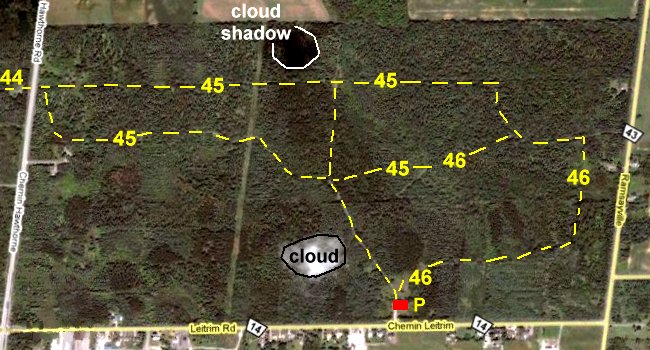 Google Satellite View of the Letrim Road East Trails
Airport Loop Route Directions: From the parking lot for the Leitrim Road East Trails, turn left or northeast onto Leitrim Road and proceed 0.7 km to Ramseyville (Baseline) Road. Turn left or NNW onto it and follow it 2.0 km to Whyteside Road. Turn left or southwest onto Whyteside and go 2.0 km to Hawthorne Road. Turn left or SSE onto it and drive 0.1 km to Davidson Road. Turn right or southwest onto it and go 0.4 km to the parking lot, on the left or south side of the road, for the next site on this route, Pine Grove Trails (Davidson Road).
Return to Airport Loop.
Return to Birding Ottawa Table of Contents.
|