Independent Directions to this Site: From Highway 417 (The Queensway) take exit 127 (Woodroffe Avenue). If travelling west, the 0.2 km offramp dumps you right or north onto Woodroffe Avenue. If driving east, a 0.3 km offramp brings you to Woodroffe, where you will turn left or north and in 0.4 km join the westbound offramp traffic. Both groups will now follow Woodroffe Avenue north 0.4 km from here to Lenester Avenue. Turn right or east onto Lenester and go 0.2 km to Fairlawn Avenue. Turn left or north onto Fairlawn and go 0.4 km to Carling Avenue. Go straight north across Carling where Fairlawn becomes Woodroffe Avenue. Follow Woodroffe north for 1.2 km to the Ottawa River Parkway. Turn left or southwest onto the Parkway and go 0.3 km to the turnoff for the Deschênes Rapids Lookout. Turn right or north into the parking lot.
Ottawa River West: Ontario Route Directions: From Kitchissippi Lookout turn right or south onto the Ottawa River Parkway. Then proceed 2.6 km southwest along the Parkway to the Deschênes Rapids Lookout turnoff. Make a right-hand turn to the north into the parking lot for the Deschênes Rapids Lookout.
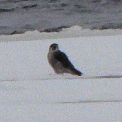
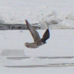
Site Description and Birding Information: This site closely resembles the last in its potential. Though it has a view of the Deschênes Rapids, it is roughly a kilometre from the "action" there. Even with a spotting scope it is tough to get good looks at the rarities which show up regularly below the rapids. However, the view is unobsturcted and sometimes birds swing along the shore nearby in search of food. Alternate views of the Deschênes Rapids can be had from both Ontario and Quebec.
In October of 2011 this site was often the best viewing area for both the Razorbill (Oct. 22 to at least Oct. 26) and the Western Grebe (Oct. 23 to at least Oct. 26). Both these birds seemed to prefer the middle of the Ottawa River, well below the rapids.
 |
 |
Ottawa River West: Ontario Route Directions: When leaving the Deschênes Rapids Lookout, turn right or southwest onto the Ottawa River Parkway and go 1.2 km southwest and south to the end of the Parkway where a right-hand turn dumps traffic unceremoniously onto Carling Avenue. Follow Carling 0.4 km west to Croydon Avenue. Turn right or north onto Croydon and proceed 0.4 km to Regina Street, crossing Richmond Road on the way. Turn left or west on Regina and go 0.3 km to Poulin Avenue. Turn right or north on Poulin and go 0.2 km to where a right only turn puts you on Howe Street. Follow Howe west 0.2 km to Britannia Road. Turn right or north onto Britannia Road and proceed 0.8 km to Cassels Street. Turn right or east onto Cassels and go 0.4 km to a small parking area on the left at the next site Britannia Conservation Area.