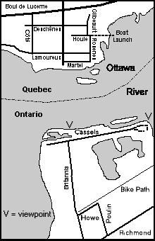
Independent Directions to this Site: From Highway 417 (The Queensway) take exit 129 (Greenbank & Pinecrest Roads). If travelling west, the 0.3 km offramp dumps you right or north onto Pinecrest Road. If driving east, a 0.3 km offramp brings you to Pinecrest/Greenbank Road, where you will turn left or north onto Pinecrest Road and in 0.4 km join the westbound offramp traffic. Both groups will now follow Pinecrest Road north 0.8 km from here to Richmond Road. Turn right or northeast onto Richmond and go 0.5 km, crossing Carling Avenue, to Poulin Avenue. Turn left or north onto Poulin and go 0.6 km to where a right only turn puts you on Howe Street. Follow Howe west 0.2 km to Britannia Road. Turn right or north onto Britannia Road and proceed 0.8 km to Cassels Street. The Britannia Yacht Club is directly in front of you. Park along Cassels Street. You will have to proceed on foot through the Yacht Club gate, walk 200 metres east past the barrier and 150 metres north to the Deschênes Rapids - Ontario. To view the area below the rapids proceed east along Cassels to the Y junction and bear left to go behind the filtration plant. Britannia Point and a good view of the swirling flock can be had here.
Ottawa River West: Ontario Route Directions: From the Britannia Conservation Area you don't even have to move your car to visit the next site. But unless you are a member of the Britannia Yacht Club, you will be obliged to walk anyway, there being a liftbar requiring a keycard blocking the road. This is private property, so be courteous and ask permission if anyone is about. You can walk west 500 metres on Cassels Road from the Conservation Area parking site to the Yacht Club gate, then walk 200 metres east past the barrier and 150 metres north to the Deschênes Rapids - Ontario. To view the area below the rapids proceed east along Cassels to the Y junction and bear left to go behind the filtration plant. Britannia Point and a good view of the swirling flock can be had here.
Site Description and Birding Information: The narrowing of the Ottawa River at the downstream end of Lac Deschênes accelerates the flow as it approaches and tumbles over a set of rapids. In early summer, the churn below the rapids attracts large flocks of gulls and terns, including rarities, to feed on the plenty. Depending on water levels, which are often fiddled with upstream, the rocks in the rapids may be exposed, providing roosting areas for gulls, mainly in summer and fall. This spot is one of the few places along the Ottawa River which stays ice-free throughout the winter, providing habitat for overwintering ducks. See also the description of the Deschênes Rapids - Quebec side.
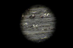
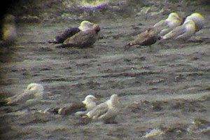
One highlight at Deschênes Rapids is in late May and early June when diligent and/or experienced observers can pick out the occasional Acrtic Tern winging its way along the river. While most often single or in small flocks, up to 90 were seen May 30, 1993. Usually only fly-bys, sometimes they hang around for awhile feeding with the congregated gulls and terns. During this period mayflies hatch in millions, providing food for fish below the rapids, and this, in turn, attracts hundreds of birds. The flocks wheel and swoop, patrolling both sides of the river and all points between. The better vantage point for this spectacle is the point north of the NE corner of the Britannia Filtration Plant, and the shoreline immediately to the west. If the wind is keeping the birds away from the Ontario side, try the boat landing off Rue Rosenes on the Quebec side, described in the Deschênes Rapids - Quebec site. Less common birds, such as Bonaparte's Gulls and Common and Black Terns are normally present in small numbers, and rarities show up regularly among the swirling Ring-billed and Herring Gulls and multitudes of swallows.
Gulls roost on the rocks that are exposed in the rapids when and if the water level drops in late summer and fall. Iceland and Glaucous Gulls can be found in early or late winter. Lesser Black-backed Gulls are seen here occasionally in spring and summer, and with some regularity in September to November. If the water is very low, shorebirds may stop to rest on migration. Less common species seen here are American Golden-Plover, White-rumped and Baird's Sandpiper and Purple Sandpiper, the latter most likely around the first week of November. The best spot to see this area from is the shore facing the rapids at the Yacht Club. The best alternative is viewing from the west end of Britannia Conservation Area's 'ridge', which runs parallel to Cassels Street and abuts the Yacht Club. Here you are set back from the best vantage points, being forced to look through a gap. But by going to the shore and moving along the ridge to the west of the main trail some reasonable views can be had.
One or two, sometimes more, Barrow's Goldeneye are usually present all winter with the flock of Common Goldeneye above the rapids. The birds rest along the upstream edge of the ice, and feed by diving above the rapids until they are near the whitewater. Then they shoot the rapids and fly back up to do it all over again. Patience and a good scope are necessary when trying to pick out the Barrow's. This is a good time to look for winter birds of prey, such as Snowy Owl, Merlin and Peregrine Falcon coming for a meal. Bald Eagle has been seen in spring and fall. Waterfowl that are late leaving in the early winter or early in spring usually wind up here to take advantage of the open water. These birds are often closer to the Quebec side of the river and may often be viewed more easily from the south end of Chemin Vanier and along the river immediately west of there on the cul-de-sac Rue Bréboeuf at the Deschênes Rapids - Quebec site.
Just before reaching the rapids on the main river channel, you will cross an old canal. Looking east, check it for waterfowl. Mergansers and rarely Harlequin Duck use this watercourse.
Rarities found at this site recently include: Thick-billed Murre (Dec. 6, 1995), Northern Gannet (flyby Oct. 8, 2001), Forster's Tern (May 224, 2004), Sabine's Gull (juv. Sep. 12-13, 2007), Harlequin Duck (Nov. 23, 2009), Franklin's Gull (May 26, 2011).
Additional information on this and nearby Ontario sites is available at the Ottawa Field-Naturalists' Club website's Britannia page.
Ottawa River West: Ontario Route Directions: From wherever you have parked on Cassels Street return to Britannia Road. Proceed south along Britannia Road 1.3 km to Carling Avenue. Turn right on Carling and go 0.2 km to Pinecrest/Greenview. Turn right onto Greenview Avenue. Follow it for 1.2 km to the parking lot at Britannia Beach. Britannia Pier is adjacent the beach.