BRITANNIA CONSERVATION AREA
Spring: **** Summer: *** Fall: **** Winter:**
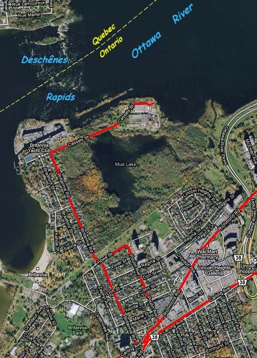 Google Satellite Map of Britannia Conservation Area
Independent Directions to this Site: From Highway 417 (The Queensway) take exit 129 (Greenbank & Pinecrest Roads). If travelling west, the 0.3 km offramp dumps you right or north onto Pinecrest Road. If driving east, a 0.3 km offramp brings you to Pinecrest/Greenbank Road, where you will turn left or north onto Pinecrest Road and in 0.4 km join the westbound offramp traffic. Both groups will now follow Pinecrest Road north 0.8 km from here to Richmond Road. Turn right or northeast onto Richmond and go 0.5 km, crossing Carling Avenue, to Poulin Avenue. Turn left or north onto Poulin and go 0.6 km to where a left only turn puts you on Howe Street. Follow Howe west 0.2 km to Britannia Road. Turn right or north onto Britannia Road and proceed 0.8 km to Cassels Street. Turn right or east onto Cassels and go 0.4 km to a small parking area on the left at the Britannia Conservation Area.
Ottawa River West: Ontario Route Directions: From Deschênes Rapids Lookout turn right or southwest onto the Ottawa River Parkway. Then go 1.2 km southwest and south to the end of the Parkway where a right-hand turn dumps traffic unceremoniously onto Carling Avenue. Follow Carling 0.4 km west to Croydon Avenue. Turn right or north onto Croydon and proceed 0.4 km to Regina Street, crossing Richmond Road on the way. Turn left or west on Regina and go 0.3 km to Poulin Avenue. Turn right or north on Poulin and go 0.2 km to where a left only turn puts you on Howe Street. Follow Howe west 0.2 km to Britannia Road. Turn right or north onto Britannia Road and proceed 0.8 km to Cassels Street. Turn right or east onto Cassels and go 0.4 km to a small parking area on the left at the Britannia Conservation Area. If you so choose, you can park along Howe Street and enter the Conservation Area from the south - look for the nearest entry gate in the fence along the bike path. There are several gates along the bike path to the east, as well. It is also possible enter from the west via Britannia Road, 0.6 km north of Howe, by turning right at the extension of Rowatt Street, parking there and entering at the gate.
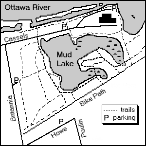 Map of Britannia Conservation Area
Site Description and Birding Information: This wooded park along the Ottawa River in the west end of the city is one of the most accessible and productive spots in the region for migration watching. Central to the site is Mud Lake, a small lake that attracts numerous waterbirds and turtles. Trails intersect much of the green space surrounding the lake. The comparatively large area of woodlands here acts as a magnet for passing landbird migrants. A low ridge between the river and lake provides viewing oppurtunities to the north. The entire site is around 1100 by 700 metres. It is owned by the National Capital Commission and City of Ottawa, and is subject to periodic proposals for its use as a bridgehead for a crossing of the Ottawa River. Should this happen, it would undoubtedly be deleterious to what's left of this beautiful spot.
Habitats include: upland early successional coniferous forest (White Pine dominated) west of Mud Lake, upland deciduous scrub vegetation east of Mud Lake, deciduous riparian forest along rivershore, buttonbush dominated thicket swamp in Mud Lake and eutrophic aquatic vegetation in Mud Lake.
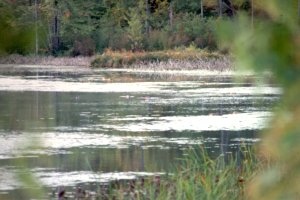
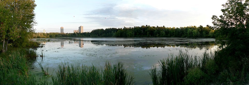 Mud Lake as seen from Cassels Street
During peak waterfowl migration, begin by scanning Mud Lake from near your parking spot along Cassels Street. During fowl weather, scanning can be done from the shelter of your vehicle along Cassels. With a spotting scope one can see the majority of the main 200 metre wide by 500 metre deep section of the lake to the SSE. Other portions of the pond are better viewed from spots mentioned later. The main section will have at least some waterfowl from the time the ice breaks up until freeze up. Good numbers can be found during migrations. Wood Duck and Pied-billed Grebe breed here. A pair of Canada Geese have nested out on the pond in recent years. Each spring Osprey can be seen roosting in trees along the lakes edge. During their migration, it is an especially good places to see swallows, as hundreds of them hawk for insects over the pond and roost on dead branches over the water. All 6 of our breeding swallows can be seen including Tree, Barn, Cliff, Bank and the less common Northern Rough-winged Swallow and the larger Purple Martin. Fall migration brings the best consentrations of waterfowl to the pond. Ten Redhead were seen there on Oct. 8, 2005.
In the peak of landbird migration, many birders will be occupied scanning the trees tops and bushes. Dont be afraid to ask other birders what theyve seen, many are friendly and enjoy being helpful.
One can profitably spend anywhere from an hour before work to a full day at Britannia. If you have only a short time, do not try to go all the way around the lake. Leave about a half day for that. It is physically possible to do the circuit in less than a hour; but if there are birds, it will take longer. For very short visits concentrate on Cassels Street and the ridge, or the trails down the west side of Mud Lake; or, if entering from the south (see below), the south side and southwest corner areas.
The following route around Britannia assumes that most of the day will be spent there. Birders can tailor it to suit their schedules and personal bents.
If parked at the paved spots near the filtration plant gates, walk back along Cassels, checking the lake on the left or south side and the wet areas on the right or north side between the road and the ridge. Near the parking area this is more open and can harbour sparrows, perhaps even a Lincolns. As one approaches the dirt parking pulloffs at the northwest corner of the pond, the wet areas on both sides are sheltered by deciduous trees. These trees are often full of flitting migrants. Often, in spring migration, a Northern Waterthrush can be found here. If one has parked here at the northwest end of the lake, it is worth walking east on Cassels to the other parking area and back again. This will bring everyone to the parking area at the northwest corner of the lake. Just to the west of that are the trailheads and turnstiles for trails to the south, going along the west side of Mud Lake; and, to the north, following the ridge.
To the west, along Cassels, weedy ditches can be filled with sparrows in the fall, White-crowneds being well-represented.
Our route will take the north trail to the "Ridge at Britannia", as it is often called. Pass the turnstile, watching for skulkers in the shadowed area at the base of the ridge, then proceed along the dirt trail up to the ridge top. An aside trail goes to the left or west as far as the Yacht Club fence, offering views of the river and roosting gulls here and there. The thick bushes on the ridge are often alive with migrants. The trail along the ridge is wide and open to the south, providing good views looking down into the sheltered area there. Birding the bushes can be challenging because of their density and the few access points overlooking the north side of the ridge. Many birds shelter there during migration, so it can be very rewarding. The viewpoints overlooking the north side of the ridge allow a non-intrusive birder opportunities to see birds forced to the back of the bushes along the ridge by other birders or dog-walkers.
The east end of the ridge is marked by a group of 6 large spruces where the trail descends to the lawn of the Water Filtration Plant. These spruces can attract conifer-loving migrants such as Blackpoll Warblers. An aside to the north here takes you into a low-lying riparian area along the channel. It is just far enough off the beaten track to allow birds to rest there and fuel up for the next leg of their trips. When the river is low enough, you can explore along the channel.
From the spruces our route follows the edge of the lawn along the river to Britannia Point. This point and the Britannia Yacht Club are viewpoints for the Deschênes Rapids. The possibilities for these sites are described in the next site along this route, Deschênes Rapids - Ontario and in the Deschênes Rapids - Quebec section. The Britannia Conservation Area and the adjacent Ontario side of the rapids are often lumped together and are known far and wide by area birders as simply "Britannia".
From the point, our route continues along the shore to the southeast. Just before reaching the swampy woods, a small bar can be seen if the water is low enough. This may attract resting gulls, terns and shorebirds. The trail runs between the filtration plant fence and the edge of the swamp, where migrants may shelter. If your time is short, cut back to the parking area along the north shore of Mud Lake. The bushes along this stretch can be very productive and there are excellent views of the lake itself. Opposite the parking area at the filtration plant gates, where we started, there is a small point going into the lake. This spot is great for waterfowl and swallow viewing in season.
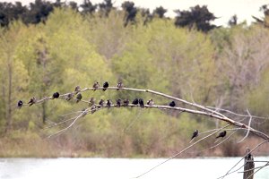 Purple Martins at Britannia
Returning to our route, instead of returning westward along the north shore of Mud Lake, we will follow the path going southeast between Mud Lake and the swamp. This can be very wet but is usually passable, sometimes with rock or plank steps. Excellent views of the swamp and lake are had here. The trail then proceeds southeast through an area of second growth and continues along the east side of Mud Lake to eventually come out at a turnstile at the SE corner of the conservation area and, beyond that, the main bike path running along the southern boundary of the conservation area. Such birds as Gray Catbird and Ruby-throated Hummingbird can be found here. There are trails leading northeast toward the swamp and the newly landscaped flood control pond adjacent the Ottawa River Parkway, and beyond to the Ottawa River. These spots can be worth checking if you have time, especially in migration.
At this SE corner, you have a choice of routes. You can take the somewhat elevated bike path which runs southwest along the conservation area and provides good viewing of a classic edge. The north or park side has woodland and swamp, while the south side has a few larger trees, then suburban housing. Access to a dry, scrubby area and some of the southern shore of Mud Lake can be had through a turnstile opposite a house with a cedar hedge. The trail leading northwest meets shortly with the alternate route mentioned next.
A second route from the SE corner is to follow the conservation area trail leading west from the turnstile area. This trail crosses a wooded swampy area and after emerging in a dry, scrubby area, it joins the trail running northwest from the bike path (the alter route just mentioned). This area has trails going toward the lake and into swampy areas that are worth exploring if you have the time. There are several views of the south shore of Mud Lake opposite the filtration plant. This area has been one of the best spots for Wilson's Warbler in migration.
It is no longer necessary to return through the turnstile to the bike path and continue southwest on it past the swampy area to the next turnstile. But is a worthy alternate route from the main trail. The swampy area at the southern end of the lake, opposite some playing fields, contains several ancient willows that can be great for migrants. Beyond the last house south of the bike path, is a turnstile and sign for the conservation area. Enter here and follow the trail through the woods. Where it turns west, take the short trail going straight into the swamp to rejoin the main trail.
It is no longer necessary to do this because the main trail now has a boardwalk across the swamp. This portion of the swamp has been a haven for turtles and the trees overhead are a local heron roost. Black-crowned Night Heron can be found here in late summer and fall. Green Heron is often present. Unfortunately, this section of the swamp has become overgrown.
On the main trail, follow the southern shore of Mud Lake westward. There are several large rocks that provide excellent viewpoints along the shore; even room to mount a scope. The buttonwood swamp here often harbours waterfowl. Wood Ducks can be seen here as long as there is open water. These trails can be muddy in spring, rubber boots might be an asset. Lower water levels in recent years have made this area somewhat less productive.
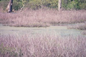 South End of Mud Lake
Proceed westward to the southwest corner of the pond. This area, in fact the entire western shore area, can be excellent for migrant land birds. There are basically three routes from here. Loosely, along the western shore, along the outer conservation area fence and less used intermediate routes. All can be very productive during migration. If you have time, sample them all. If you are pressed for time, stick to the "shore" route.
The second growth woods in the southwest corner are well worth checking if you have time for migrant land birds. The intermediate routes are little used and poorly marked, but a quiet and cautious birder can be rewarded with skulkers. The southern woods have produced uncommon migrants like Blue-gray Gnatcatcher (April 28, 2004).
 West Side of Mud Lake
West of the southeast end of Mud Lake is a stand of mature white pine which sustains a small colony of Pine Warbler and, in some years, breeding Great Horned Owls. As we go northwest along the main trail, we move from the pines into an area of mature hardwoods. This is a good spot for high-canopy migrants, but very hard on the neck. Scarlet Tanager, various vireos and warblers can be seen here as they pass through.
The outer loop passes through more open areas, including stands of sumac. Midway along the western fence is an active Purple Martin colony. The intermediate loop passes through some areas with massive tangles. These can be very rewarding if you are patient.
Continuing northwest you will come out through the turnstile to Cassels Street, opposite the turnstile where you entered to climb the ridge. Bird the road here again as you return to you vehicle (to the northeast, if you parked in the paved lot).
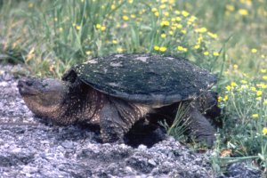 Snapping Turtle Laying Eggs along Cassels Street
Rarities seen at Britannia include:
Cassin's Kingbird (Sep. 19 - Oct. 9, 1970),
Prairie Warbler (Aug. 31, 1973 & May 13, 1975),
Hooded Warbler (Jul. 30, 1975),
White-eyed Vireo (Oct. 8, 1978),
Gray Kingbird (Oct. 31, 1982),
Prothonotary Warbler (May 24, 1984 & May 20, 1997),
Gyrfalcon (Jan. 11, 1987 & Mar. 18 & 31, 1991),
Worm-eating Warbler (May 15, 1987),
Connecticut Warbler (Sep. 6, 1987 - ridge; Aug. 31, 1988; Sep. 29, 1990; Aug. 19, 2006 - ridge; Sep. 2, 2009 - ridge),
Eurasian Wigeon (Sep./Oct. of 1987 to 1991),
Yellow-breasted Chat (Sep. 25, 1988),
Black-legged Kittiwake (Sep. 30, 1990),
Harlequin Duck (2 on Dec. 4-5, 1994 & Nov. 22 - Dec. 1, 2002),
Great Egret (Aug. 28, 1995, flyby June 5, 2005 & mid-Sept. 2007),
Thick-billed Murre (Dec. 6, 1995 - rapids),
Franklin's Gull (Jun. 3, 1996, May 26, 2011),
Little Blue Heron (Aug. 7-11, 1998),
Northern Gannet (flyby Oct. 8, 2001),
Forster's Tern (May 24, 2004),
Caspian Tern (May 11, 2005),
Carolina Wren (Oct. 21, 2006; Apr. 19 & 23, 2008),
Sabine's Gull (Sep. 12-14, 2007 - below rapids; Sep. 17, 2010 - below rapids),
Parasitic Jaeger (Sep. 26, 2010 - below rapids),
Blue-winged Warbler (May 25, 2011).
Additional information on this and nearby sites is available at the Ottawa Field-Naturalists' Club website's Britannia page.
Ottawa River West: Ontario Route Directions: You don't even have to move your car to visit the next site. But unless you are a member of the Britannia Yacht Club, you will be obliged to walk anyway, there being a liftbar requiring a keycard blocking the road. You can walk west 500 metres on Cassels Street from the Conservation Area parking site to the Yacht Club gate, then walk 200 metres east past the barrier and 150 metres north to the next site Deschênes Rapids - Ontario.
Return to Ottawa River West: Ontario.
Return to Birding Ottawa Table of Contents.
|