COBBS LAKE CREEK NORTH of ETTYVILLE
Spring: *** Summer: ** Fall: ** Winter: *
Independent Directions to this Site: From Highway 417 (The Queensway) take exit 96 (Boundary Road). Proceed 2.0 km NNW on Boundary Road to Russell Road (Regional 26). Turn right or ESE onto Russell Road (Regional 26, then Prescott - Russell 2) and drive 34.5 km, through Bourget, to Prescott - Russell 19. Turn right or SSE onto it toward Pendleton and proceed 4.5 km SSE through Pendleton to the Ettyville Road. Turn right or WSW onto it and travel 3.0 km to Johnston Road. Turn right or NNW onto it and proceed c. 1 km to view the floodplain at Cobbs Lake Creek North of Ettyville.
Spring Flooding Route Route Directions: From the bridge over Cobbs Lake Creek at the South Nation River on Prescott - Russell 19 go south 0.4 km to the Ettyville Road. Turn right or WSW onto it and travel 3.0 km to Johnston Road. Turn right or NNW onto it and proceed c. 1 km to view the floodplain at Cobbs Lake Creek North of Ettyville.
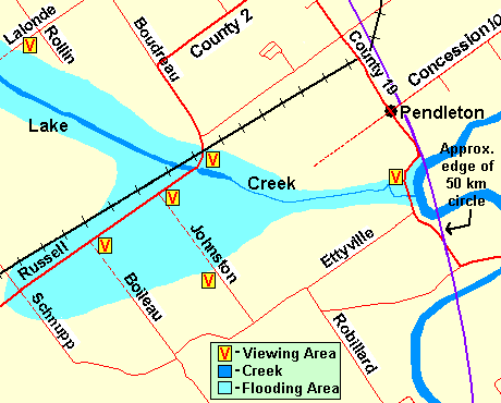 Map of Cobbs Lake Creek North of Ettyville area
Site Description and Birding Information: Johnston Road runs between Russell Road and the Ettyville Road. It's northern half runs across the floodplain and during the most widespread flooding, this section is under water. Often there are large flocks of waterfowl that can be seen better from the south side, our present site, than from the northern site, Cobbs Lake Creek at Russell Road (Bourget).
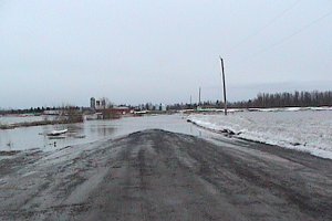 Cobbs Lake Creek North of Ettyville
This site has had over 100,000 Canada Geese on several occasions, and over 10,000 normally during the spring floods. Snow Geese are seen here in significant numbers as well, some years over a thousand, rarely even more. Northern Pintail are the most abundant duck, usually over 1,000, rarely to 10,000. Mallard, Black Duck and Green-winged Teal are common. Canvasback has been a repeat visitor. Greater White-fronted Geese have occurred, 3 together on Mar. 26, 1988.
Raptors find good hunting here, especially during the floods. Rough-legged Hawk and Northern Harrier have occurred in good numbers some years. Merlin, Snowy Owl and Short-eared Owl have also been found. Both Northern and Loggerhead Shrike have been seen in the area at the end of March, beginning of April period. Vesper Sparrows, which breed in the area, arrive in early April. In late March, the first Tree Swallows can meet a flock of thousands of Snow Buntings on their way north.
Rarities seen here include Sandhill Crane (Mar. 28, 1990), Tundra Swan (Apr.1-8, 1991), Northern Hawk Owl (2 km west of Bourget Feb. 28, 1993), Ross' Goose (2 on Apr. 12, 2003).
You may also wish to try to view the floodplain from Boileau Road, 1.4 km to the east of Johnston Road along the Ettyville Road. However, Johnston Road is the best viewing area on the southern side.
Spring Flooding Route Route Directions: From Cobbs Lake Creek North of Ettyville return SSE on Johnston Road c. 1 km to the Ettyville Road. Turn left or ENE onto it and go 3.0 km to Prescott - Russell 19. Turn right or SSE onto P-R 19 and proceed 3.3 km to Prescott - Russell 16. Turn left or northeast onto P-R 16 and travel 9.3 km to Prescott - Russell 9, just east of Riceville. Turn left or NNW onto P-R 9 and go 1.9 km to Concession 12. Turn left or west onto it to begin the next site on this loop, South Nation River north of Riceville.
Return to Spring Flooding Route.
Return to Birding Ottawa Table of Contents.
|