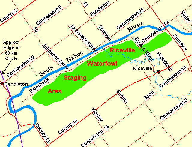
SOUTH NATION RIVER NORTH of RICEVILLE
Spring: **** Summer: ** Fall: ** Winter: *
Independent Directions to this Site: From Highway 417 (The Queensway) take exit 51 (St. Isadore de Prescott exit) and proceed north on Prescott - Russell 9 for 13.5 km (through St. Isadore) to Concession 12. Turn left or west onto it to begin viewing the waterfowl staging area along the South Nation River north and west of Riceville.
Spring Flooding Route Route Directions: From Cobbs Lake Creek North of Ettyville return SSE on Johnston Road c. 1 km to the Ettyville Road. Turn left or ENE onto it and go 3.0 km to Prescott - Russell 19. Turn right or SSE onto P-R 19 and proceed 3.3 km to Prescott - Russell 16. Turn left or northeast onto P-R 16 and travel 9.3 km to Prescott - Russell 9, just east of Riceville. Turn left or NNW onto P-R 9 and go 1.9 km to Concession 12. Turn left or west onto it to begin viewing the waterfowl staging area along the South Nation River north and west of Riceville.
 Map of the South Nation River north and west of Riceville
Site Description and Birding Information: Note: For Ottawa Checklist purposes, this site is outside the 50-km circle. To bird the entire area encompassed by this site, follow Concession 12 for 1.9 km to Scotch River Road, turn right or northwest on it and go 0.4 km to Riverbend Road. Turn left onto Riverbend and follow it as far as you are able, usually c. 4.3 km. A further 3.0 km of "road", impassible in spring, extends WSW to nearly reach the 50-km OFNC checklist circle. Walking is not recommended, since people on foot seem to frighten the waterfowl more than a vehicle. A car makes a good blind for scoping the large flocks of mainly Canada Geese.
This site has had 25,000 to 50,000 or more Canada Geese on many occasions, and over 10,000 normally during the spring floods. Snow Geese are seen here in significant numbers as well, some years over a thousand, rarely, though more commonly recently, even more. On Apr. 6, 2005, 7,500 were seen here. Northern Pintail are the most abundant duck, usually over 1,000, rarely to 10,000. Mallard, Black Duck and Green-winged Teal are common. Northern Shoveler, Gadwall, Ring-necked Duck, Blue-winged Teal, American Wigeon are all regular in smaller numbers. Greater White-fronted Goose has occurred (Apr. 2, 1987) and Ross's Goose (Apr. 21, 2007).
Raptors find good hunting here, especially during the floods. Rough-legged Hawk and Northern Harrier have occurred in good numbers some years. Short-eared Owl have also been seen in late March. American Tree Sparrows and Rusty Blackbirds can both be found in the bushes along the river in April.
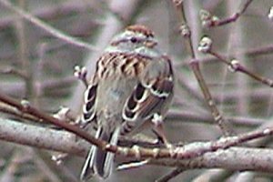 Americam Tree Sparrow - Riverbank Road - April 10, 2004
|
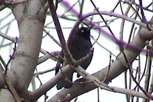 Rusty Blackbird - Riverbank Road - April 10, 2004
|
An eastern extension of this area, but on the north side of the South Nation River, has recently had large flocks of both Canada Goose and Snow Goose. The largest single flock of Snow Goose ever seen near the Ottawa Checklist Circle was seen here on April 17, 2008, estimated at over 50,000. This area is reached by crossing the South Nation River northward on County Road 9 and taking a right almost immediately on Concession 12, to the ENE. After one kilometer you will reach Vallee Road on the right or SSE. For best viewing of this area take Vallee Road, if it remains open, to scan the flooded fields along the river.
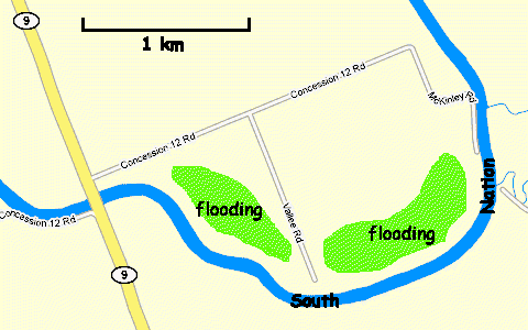 Google Map of the South Nation River East of the Riceville Area
Spring Flooding Route Route Directions: This is the final site on the Spring Flooding Route. From here you may return through St. Isadore to Highway 417 to go back to Ottawa. Alternately, you might visit the nearby Alfred Bog and Lagoons site. Or you could jump to another route such as the Eastern Sewage Lagoons Route or the Larose Forest Loop. The nearest lagoons are at St. Isadore.
Return to Spring Flooding Route.
Return to Birding Ottawa Table of Contents.
|