COBBS LAKE CREEK at RUSSELL ROAD (BOURGET)
Spring: **** Summer: ** Fall: ** Winter: *
Independent Directions to this Site: From Highway 417 (The Queensway) take exit 96 (Boundary Road). Proceed 2.0 km NNW on Boundary Road to Russell Road (Regional 26). Turn right or ESE onto Russell Road (Regional 26, then Prescott - Russell 2) and drive 26.5 km, through Bourget, to descend into the 3.8 kilometre extent of the floodplain area of the Cobbs Lake Creek at Russell Road (Bourget) site.
Spring Flooding Route Route Directions: From Cobbs Lake Creek at Lalonde Road, return ENE to Rollin Road and then continue ENE on Lalonde 1.2 km to Boudreau Road and turn right or SSE onto it. Proceed 1.5 km to Prescott - Russell 2 and turn right (actually to go straight) onto it. Continue SSE 1.5 km on P-R 2 to the sharp righthand curve where P-R 2 is also called Russell Road. The next 3.8 kilometres, from the corner to the beginning of the hill going up into the town of Bourget, are the Cobbs Lake Creek at Russell Road (Bourget) site.
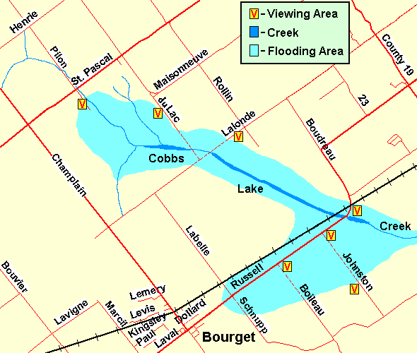 Map of Cobbs Lake Creek at Russell Road (Bourget) area
Site Description and Birding Information: This is the fourth, and undoubtedly the best, in a series of spots from which to view the Cobbs Lake Creek floodplain. Park along the road, which offers a slightly elevated position to set up your scope. The vast extent of this area is one of its drawbacks, the birds often stay well away from the road. A good scope is essential. The old railbed also provides an elevated, and dry, path through a portion of the floodplain.
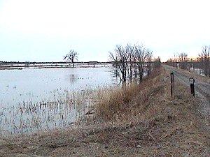 Old Railbed Providing Viewing Platform
|
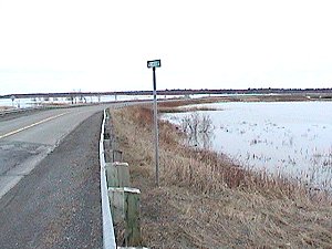 Russell Road Crossing the Floodplain Area East of Bourget
|
The sideroads (Johnston, Boileau and Schnupp Roads) crossing the flooded area to the SSE are usually blocked off during flood season. Schnupp is the most likely to be open, and may allow access to the Ettyville or south side of the floodplain. Going north on Johnston or Boileau from the Ettyville Road will allow viewing the southern side of the area. This is not always accessible from Russell Road and an alternate route through Pendleton is described in the Cobbs Lake Creek North of Ettyville site.
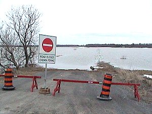 Flooded Sideroad to Ettyville
This site has had over 100,000 Canada Geese on several occasions, and over 10,000 normally during the spring floods. Snow Geese, increasing now, are seen here in significant numbers as well, some years over a thousand, rarely even more. Northern Pintail are the most abundant duck, usually over 1,000, rarely to 10,000. Mallard, Black Duck and Green-winged Teal are common. Canvasback has been a repeat visitor. Greater White-fronted Geese have occurred a number of times, 3 together on Mar. 26, 1988 and 2 on Mar. 25, 2007.
Raptors find good hunting here, especially during the floods. Rough-legged Hawk and Northern Harrier have occurred in good numbers some years. Merlin, Snowy Owl and Short-eared Owl have also been found. Both Northern and Loggerhead Shrike have been seen in the area at the end of March, beginning of April period. Vesper Sparrows, which breed in the area, arrive in early April. In late March, the first Tree Swallows can meet a flock of thousands of Snow Buntings on their way north.
Rarities seen here include Sandhill Crane (Mar. 28, 1990), Tundra Swan (Apr.1-8, 1991), Northern Hawk Owl (2 km west of Bourget Feb. 28, 1993), Ross' Goose (2 on Apr. 12, 2003), Eurasian Wigeon (Apr. 2, 2006; Mar. 30 to Apr. 3, 2009), Great Egret (Apr. 17, 2008).
Spring Flooding Route Route Directions: Return to the sharp corner on Russell Road (Prescott - Russell 2) at the east end of the Cobbs Lake Creek at Russell Road (east of Bourget) site and continue left or NNW around the corner on it. After 1.5 km continue to follow P-R 2 as it makes a sharp righthand turn and heads ENE. Drive a further 2.6 km to Prescott - Russell 19 and turn right or SSE onto it toward Pendleton. Proceed 3.5 km SSE through Pendleton to a sharp righthand turn at the South Nation River. Continue around the corner to study the next site on this loop, Cobbs Lake Creek at the South Nation River.
Return to Spring Flooding Route.
Return to Birding Ottawa Table of Contents.
|