COBBS LAKE CREEK at the SOUTH NATION RIVER
Spring: ** Summer: * Fall: * Winter: *
Independent Directions to this Site: From Highway 417 (The Queensway) take exit 96 (Boundary Road). Proceed 2.0 km NNW on Boundary Road to Russell Road (Regional 26). Turn right or ESE onto Russell Road (Regional 26, then Prescott - Russell 2) and drive 34.5 km, through Bourget, to Prescott - Russell 19. Turn right or SSE onto it toward Pendleton and proceed 3.5 km SSE through Pendleton to a sharp righthand turn at the South Nation River. Continue around the corner to study Cobbs Lake Creek at the South Nation River.
Spring Flooding Route Route Directions: From Cobbs Lake Creek at Russell Road (Bourget), return to the sharp lefthand turn at the east end of the Cobbs Lake Creek at Russell Road east of Bourget area and continue left around the corner or NNW on Prescott - Russell 2. After 1.5 km continue to follow P-R 2 as it makes a sharp righthand turn and heads ENE. Drive a further 2.6 km to Prescott - Russell 19 and turn right or SSE onto it toward Pendleton. Proceed 3.5 km SSE through Pendleton to a sharp righthand turn at the South Nation River. Continue around the corner to study Cobbs Lake Creek at the South Nation River.
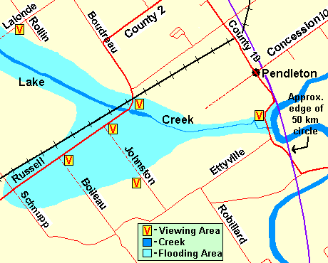 Map of Cobbs Lake Creek at the South Nation River area
Site Description and Birding Information: Here where Cobbs Lake Creek flows into the South Nation River, is yet another site at which to check the floodplain for waterfowl, especially geese. The flooding is usually less extensive here, but none-the-less worth a brief check. The road is sometimes closed due to flooding. A Greater White-fronted Goose was found here on April 6, 2005.
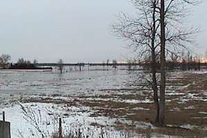 Cobbs Lake Creek at the South Nation River
Spring Flooding Route Route Directions: From the bridge over Cobbs Lake Creek at the South Nation River on Prescott - Russell 19 go south 0.4 km to the Ettyville Road. Turn right or WSW onto it and travel 3.0 km to Johnston Road. Turn right or NNW onto it and proceed c. 1 km to view the next site on this loop, Cobbs Lake Creek North of Ettyville.
Return to Spring Flooding Route.
Return to Birding Ottawa Table of Contents.
|