CORKSTOWN ROAD & TRAILS
Spring: ** Summer: * Fall: ** Winter: **
Independent Directions to this Site: From Highway 417 (The Queensway) take exit 134 (Moodie Drive). If travelling west, the 0.3 km offramp dumps you right or north onto Moodie. If driving east, a 0.3 km offramp brings you to Moodie Drive, where you will turn left or north onto it and in 0.5 km join the westbound offramp traffic. Both groups will now follow Moodie Drive north 0.2 km from here to Corkstown Road. Turn left or west into Corkstown Road.
Stony Swamp Loop Route Directions: From Highway 417 (The Queensway) take exit 134 (Moodie Drive). If travelling west, the 0.3 km offramp dumps you right or north onto Moodie. If driving east, a 0.3 km offramp brings you to Moodie Drive, where you will turn left or north onto it and in 0.5 km join the westbound offramp traffic. Both groups will now follow Moodie Drive north 0.2 km from here to Corkstown Road. Turn left or west into Corkstown Road.
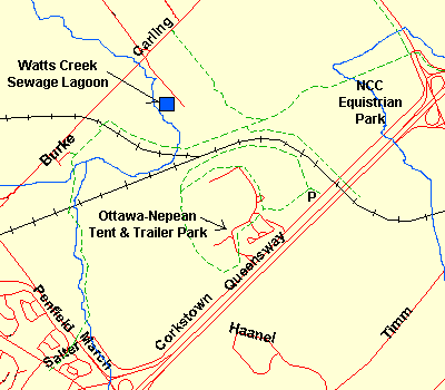 Map of Corkstown Road area
Site Description and Birding Information: This road, beginning at the Moodie Drive or eastern end, offers a variety of habitat and several opportunities to explore on foot. As soon as you turn onto Corkstown Road, it makes a hard left. Stop at this corner to scan the edge of the woods to the NW. This swampy wood along Stillwater Creek has had a heronry for many years, with several Great Blue Heron nesting there. In the Great Gray Owl invasion of 2004 - 05, a bird was seen here on both Jan. 9 and 16, 2005. Also from this corner, where there is ample room to pull off the road and park, there are bikepaths going north, west and east. These make good walking trails as well. In fact, the westward branch forms part of the new Trans Canada Trail. That trail follows the northern edge of the NCC Equestrian Park and makes the first left branch to take you south to Corkstown Road, near the rail crossing. About 0.7 km along the northerly bike path is the Moodie Drive Marsh & Trails site from the Ottawa River West: Ontario Route.
Corkstown Road runs parallel to Moodie Drive for another 0.4 km before veering SW to parallel Highway 417. To the north for the next 1.3 km lies the National Capital Commission Equestrian Park. There are grassy fields here for the horses to graze on which also attract geese during spring and fall. Also seen are grass-loving shorebirds especially in their late summer - fall passage. Black-bellied and the odd Lesser Golden Plover have been seen here. Sedge Wrens were discovered singing in the marshy area at Moodie Drive and Corkstown Road in June 2005. Glossy Ibis has been seen here (May 17, 2003) and farther along the road near the campground entrance (May 16, 2007).
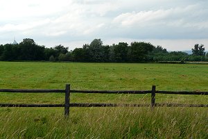 View of National Capital Commission Equestrian Park Fields along Corkstown Road
About 1.8 km along Corkstown you will cross the railway tracks. Just before you reach the tracks is where the Trans Canada Trail crosses the road. This is a good spot to access it from, but the parking is difficult. This trail joins one coming from Moodie Drive and then continues to the Watts Creek Trails site.
Parking is easier just beyond the tracks (0.2 km), on the right, where there is an NCC parking area (P3) for the trails in and around the Ottawa Municipal Campground (whose road entrance is on the right 0.9 km beyond the tracks, but is closed to all but campers in summer). From P3, the trail system consists of a 3.7 km loop, with a smaller 2.7 km loop nested within it on the SW side. The trails go through a good variety of habitat. They have some moderately hilly sections and can be very wet in spring.
The rail line can also be walked, bearing in mind the attendant dangers of same. It provides a somewhat elevated and clearer view than that from the trails, but is more difficult to walk. There are fences or ditches along much of the railway, but there are spots where one may cross from the campground trail, over the tracks, and onto the NCC trails to the north. Look for beaten paths.
The section along the tracks and NCC trail just to the north of the campground area has lots of tangles and wild food. This is very attractive to fall migrant landbirds.
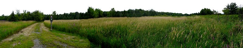 View of Corkstown Road Trail Area from P3
If you have done this loop so that you've finished it here, rather than beginning it here, and have time to spare, the following Ottawa River West: Ontario sites are near the Moodie Drive (or eastern) end of Cookstown Road: Nortel (Moodie Drive) Marsh & Trails, Ottawa Beach, Andrew Haydon Park, Stillwater - Dick Bell Park, Grandview Drive, Carling Avenue Trail and Watts Creek Sewage Lagoons .
Stony Swamp Loop Route Directions: From the WSW end of Corkstown Road turn left or SSE onto Eagleson Road. Proceed 1.4 km SSE on Eagleson Road to Timm Drive. Turn left or east onto Timm Drive and go 1.5 km to a parking lot on the right just before Haanel Drive. Park here to hike this loop's next site, the Timm Drive & Trails.
Return to Stony Swamp Loop.
Return to Birding Ottawa Table of Contents.
|