CHAMPLAIN BRIDGE
Spring: ** Summer: ** Fall: ** Winter: *
Independent Directions to this Site: From where Autoroute l'Outaouais or Highway 50 crosses over Autoroute de la Gatineau or Highway 5, the two major roads converging on Hull, continue on Hwy 50 south 1.3 km to Rue Montcalm. Turn left or southwest on Montcalm and follow it for 0.8 km to Boulevard Alexandre-Taché. Turn right or west on Taché and go 2.0 km to Rue Boudria. Turn right or south on Boudria and proceed 0.1 km to Rue Brunet. Turn right or west on Brunet and proceed 1.5 km to Place Samuel-de-Champlain and the base of the Champlain Bridge. Go directly across the junction and proceed 0.1 km along Boulevard de Lucerne. Turn left or southeast into the NCC's Samuel-de-Champlain parking lot.
Ottawa River West: Quebec Route Directions: From Taché Gardens Woods, return south the 0.4 km on Rue St.-Dominique to Boul. Taché. Turn left or east on Taché and go 0.5 km to Rue Boudria. Turn right or south on Boudria and proceed 0.1 km to Rue Brunet. Turn right or west on Brunet and proceed 1.5 km to Place Samuel-de-Champlain and the base of the Champlain Bridge. Go directly across the junction and proceed 0.1 km along Boulevard de Lucerne. Turn left or southeast into the NCC's Samuel-de-Champlain parking lot.
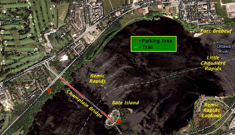 Google Satellite Map of Champlain Bridge Area
Site Description and Birding Information: The bicycle path along the Ottawa River continues along this stretch through deciduous woodland. To the east of the bridge, it runs along the riverbank and along a narrow strip of land between a back-channel and the main river. Heading east, upon leaving the trees, watch for Purple Martin hawking between the river and their martin-house just west of the school. To the west, it runs through taller deciduous woodland near the river. Yellow-throated Vireo is reported from this area nearly every spring. Both sides are excellent for migrants in season.
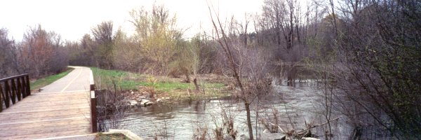 Along the Bike Path East of the Champlain Bridge
Excellent view of Remic Rapids from the Champlain Bridge sidewalk. There are a three small view points along the bridge between the Quebec shore and Bate Island that are large enough to set up a scope. The traffic in rush hour may put you off though. This site is adjacent the aforementioned Bate Island site on the Ottawa River West - Ontario route. Because of the islands here, the main channel of the river narrows to 500 metres. This makes it ideal for viewing passing gulls, terns, waterfowl, and sometimes jaegers.
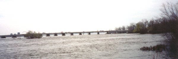 Champlain Bridge
During the peak of gull and tern activity at Deschênes Rapids - Ontario or Quebec, it is a good idea to watch for patrolling birds working along the river. Less common birds, such as Bonaparte's Gulls and Common and Black Terns can be present, and rarities like Caspian Tern can show up along with the more common birds.
Jaegers, though rare in this neck of the woods, have been seen passing this area more often than anywhere else in our area. Parasitic are the most likely, though Pomarine and Long-tailed have both occurred. Based on all reports in the Ottawa checklist area, September is the best month to watch for Parasitic's, though a few have been seen in June. Pomarine's have occurred from mid-September to mid-November. Almost all Long-tailed's that have been spotted near Ottawa, have occurred in June. Since these birds are either on their way to the arctic or coming back from it, they rarely linger here and are typically flying purposefully along the river, occassionally harrassing some unlucky tern or gull to make it cough up a meal.
An immature male Harlequin Duck wintered east of the Champlain Bridge in 2000-2001. A female spent the winter of 2007-08 east of the bridge between the Quebec shore and Bate Island. On Oct. 27, 2011 a Parasitic Jaeger rested for most of the day on the rocks by the base of the bridge.
A colony of Cliff Swallows nests under the Champlain Bridge.
 Cliff Swallow Gathering Nesting Material (mud)
For those keeping provincial lists, the Ontario/Quebec boundary is about 350 metres from the Quebec shoreline and 200 metres from Bate Island to the southeast. Alternate parking is available on Bate Island itself.
Ottawa River West: Quebec Route Directions: From the NCC's Samuel-de-Champlain parking lot, turn right or ENE onto Lucerne and go 0.1 km to Place Samuel-de-Champlain. Turn left or northwest onto Place Samuel-de-Champlain and drive 0.2 km to Chemin d'Aylmer (the old Hwy 148). Turn left or WSW onto Aylmer (the Upper Aylmer Road, as anglophones know it) and go 1.4 km to Chemin Allen. Turn right or north onto it and proceed 0.6 km to Chemin McConnell. Turn right or east on McConnell and go 0.1 km to the end. The next site on this route, Champlain Park Woods, is on your left.
Return to Ottawa River West: Quebec.
Return to Birding Ottawa Table of Contents.
|