|
|
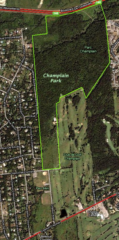 Google Satellite Map of the Champlain Park Area
|
Ottawa River West: Quebec Route Directions: From the NCC's Samuel-de-Champlain parking lot at the base of the Champlain Bridge, turn right or ENE onto Lucerne and go 0.1 km to Place Samuel-de-Champlain. Turn left or northwest onto Place Samuel-de-Champlain and drive 0.2 km to Chemin d'Aylmer (the old Hwy 148). Turn left or WSW onto Aylmer (the Upper Aylmer Road, as anglophones know it) and go 1.4 km to Chemin Allen. Turn right or north onto it and proceed 0.6 km to Chemin McConnell. Turn right or east on McConnell and go 0.1 km to the end. The Champlain Park Woods are on your left.
Site Description and Birding Information: This is yet another area decimated by urban expansion. New subdivisions on either side of the Royal Ottawa and Champlain Golf Clubs and a new highway to the north (148) have severely diminished the size of the former "natural" area made up largely of abandonned farmland. These overgrown fields, reverting to woodland, still provide a refuge for some birdlife this close to the city. But it is not as likely to attract a Great Gray Owl as it did in 1987.
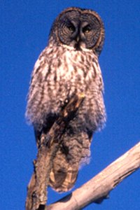 Great Gray Owl - Champlain Park - Jan. 17, 1987
The northern park of the park still has a half kilometer square block of woodland. There is a bike path (ski trail in winter) south of the new Autoroute de l'Outaouais that roughly parallels a brook toward the north of this site. The highway is 1.8 km north of Chemin McConnell.
Ottawa River West: Quebec Route Directions: From the east end of McConnell, return west 0.1 km to Chemin Allen and turn left or south onto it. Proceed 0.6 km back to Chemin d'Aylmer and turn left or ENE onto it. Go 1.4 km to Place Samuel-de-Champlain and turn right or southeast onto it. Drive 0.2 km to Boulevard Lucerne and make a righthand turn onto it. Go 1.7 km to the NCC's Chaudière parking area on the left. Turn left or southeast into this parking lot near the next site on this route, the Chaudière Area.
Return to Ottawa River West: Quebec.
Return to Birding Ottawa Table of Contents.
|