INNES POINT
Spring: *** Summer: * Fall: *** Winter: *
Warning: The site is not open to the public. It is Department of National Defense land and the only access by birders is as part of the bird banding operation there. If you are particularly interested in banding here, you will, no doubt, be welcomed by the banding group. Contact them by email at ipbo@mac.com. See the Innis Point Bird Observatory website for additional information.
Opportunity: The Innis Point Bird Observatory is calling for volunteers to help in the Spring 2003 migration. For more details visit the Birding Ottawa Eco-News page. To volunteer call Peter Browne at 613-745-1303 or e-mail him at pbrowne@cyberus.ca. This is a rare opportunity to bird Innis Point!
Independent Directions to this Site: From Highway 417 (The Queensway) take exit 138 (Eagleson/March Roads). If travelling west, the 0.6 km offramp sends you right or north onto March Road. If driving east, a 0.4 km offramp brings you to Eagleson Road, where you will turn left or north onto it and in 0.5 km join the westbound offramp traffic on March Road (it changed names as you went under the overpass). Both groups will now follow March Road northwest 8.0 km to Dunrobin Road. Turn right or north onto Dunrobin and go 0.2 km to Riddell Road. Turn right on Riddell and go northeast 4.4 km to its end. The road to Innes Point is on the right.
Ottawa River West: Ontario Route Directions: At the northeastern end of Riddell Road, where the main road goes left onto 6th Line, the gated road to Innes Point is on the right.
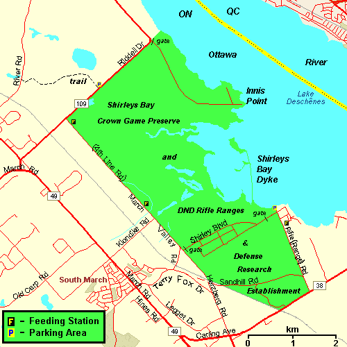 Map of the Innes Point area
Site Description and Birding Information: The banding station at Innes Point has operated for many years and produced many good birds. It is ideally situated on a point of land extending southward into Shirley's Bay, the opposite end of the bay from the Shirley's Bay Dyke.
The observatory is one of a chain of about twenty such stations across Canada at which the Spring Migration Monitoring Program is performed. The countrywide program is organized by Bird Studies Canada. The purpose is to monitor, in a standardized way, the migration of birds which are on their way to breeding grounds lying to the north of populated areas, and which are therefore relatively inaccessible to direct observation. Most of the birds concerned are small song birds. The long-term plan is to use the migration monitoring data as a measure of the populations of these northern nesters. Changes in population measures are used to guide conservation and protection programs. An owl banding project here has seen good numbers of Northern Saw-whet Owls banded in late September and in October (115 in 2003).
Rarities seen at this site include: Orchard Oriole (Jun. 5, 1987), Connecticut Warbler (banded late Aug. 1993), Black Vulture (Apr. 28, 2001), Tricolored Heron (May 11 - 14, 2001), Red-bellied Woodpecker (May 22, 2009), Caspian Tern (16 seen Aug. 18, 2010).
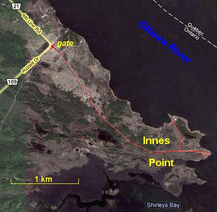 Google Satellite View of Innes Point
Ottawa River West: Ontario Route Directions: From the northwestern end of Riddell Road, go straight onto the main road as it make a right angle turn to the northwest and becomes Sixth Line Road. Follow Sixth Line 1.0 km to the parking area on the right or northeast for the next site, Riverfront Park.
Return to Ottawa River West: Ontario.
Return to Birding Ottawa Table of Contents.
|