SHIRLEYS BAY DYKE
Spring: *** Summer: ** Fall: **** Winter: *
Warning: Permission to access the dyke must be obtained by contacting the DND's Connaught Firing Range Control Office at (613) 991-5740. This phone is manned 24-7. If the dyke is the primary goal of your day's birding, it would be wise to call ahead as there are no phones at the boat launch. Shooting is often in progress and some of the bullets could stray toward the dyke. Remember they are there because they need the practice. As far as I know no birders have been winged yet and the DND has enough trouble with PR that they will do everything they can to avoid it. Please don't enter the area without permission, and please abide by Range Control's instructions. They will tell you whether or not walking the dyke is allowed. If they say no, DO NOT ENTER!, you may be shot (you just never know how good the guy practising might be), or you may be corralled by the military police (MP's). Disregarding the DND's safety measures could also jeopardise all birder's access. However, that being said, it's usually okay to bird from the gate at the base of the dyke.
Independent Directions to this Site: From Highway 417 (The Queensway) take exit 134 (Moodie Drive). If travelling west, the 0.4 km offramp dumps you right or north onto Moodie. If driving east, a 0.3 km offramp brings you to Moodie Drive, where you will turn left or north onto it and in 0.5 km join the westbound offramp traffic. Both groups will now follow Moodie Drive north 1.3 km from here to Carling Avenue. Turn left or northwest on Carling and go 2.2 km to Rifle (Range) Road. Turn right or north onto Rifle Road and travel 2.0 km to the boat launch parking lot. Park here to visit this site on foot.
Ottawa River West: Ontario Route Directions: Exit the Shirleys Bay Cottage Area via Lois Avenue. Turn right or north onto Rifle (Range) Road. Go 0.3 km to the boat launch parking area at the north end of Rifle Road on Shirleys Bay. This is where you will park to visit the Shirleys Bay Dyke.
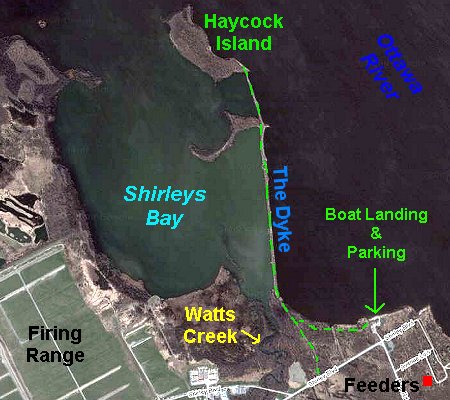 Google Satellite Map of Shirleys Bay Dyke Area
Site Description and Birding Information: This one by two kilometre bay along the Ottawa River is part Wildlife Sanctuary, part Department of National Defence (DND) shooting range. The DND owns the land around the bay, which is one of the most productive birding sites near Ottawa. Because of the shooting, access is restricted. See the warning above.
This site is exceptionally good during migration. This includes from spring thaw to winter freeze up, with the exception of the last two weeks of June.
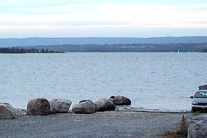 View of Shirleys Bay from the Boat Landing
From the parking lot area at the boat launch, be sure to scan the open bay for waterbirds. Your car can be a combination blind and windbreak (useful on cold early winter days). The trail from the boat launch parking lot that used to lead west toward the dyke is no more. The DND has done some 'landscaping' with bulldozers, clearing a swath from Shirley Blvd to the river along the edge of their land and erecting a tall fence. The work done here and all around this DND land shows a disheartening disregard for the environment and cannot be completely justified as a safety measure. You must now walk the shoreline to the dyke. You will want to take a spotting scope to get the most from this walk. Morning is the best time, as the afternoon sun can make viewing difficult, though not impossible.
The woods between here and the dyke are good for migrant passerines. Where the shoreline encounters the dyke, you will see the old roadway from Shirley Boulevard to the dyke. Here you can turn right to go out on the dyke or left back to where the old sewer line crosses, then right along the sewer line to reach the Watts Creek outflow, where the waste water pours out warm and keeps a small patch of water open in even the coldest winter, often reaching to the mouth of the creek (which is visible from the base of the dyke). This spot is where any dabbling ducks which are unable, for whatever reason, to go south to escape the worst of our winter, tend to congregate. A good spot for land birds is the woods near the base of the dyke. It hosted a Yellow-billed Cuckoo on June 26, 2005, a Blue-gray Gnatcatcher on August 12, 2005, and a Yellow-throated Warbler on Sep. 25, 2005.
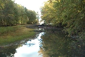 View of Watts Creek Outlet
Going back toward the dyke, you would pass through a wet swamp and come out of the woods with the Ottawa River (Shirleys Bay) to the east side and the exit of Watts Creek into Shirleys Bay on the other. The DND has placed a gate at the base of the dyke, beyond which you require permission to go. You can scan part of the interior side of the dyke without breaking the law, but make sure you call before going out on the dyke. Not only for your safety, but to insure birders continue to be allow access. Taking care not to flush the assembled multitude, set up your scope and scan. The area near the creek mouth and along the far side of the bay adjacent to it is usually where shorebirds congregate during their migrations. All Ottawa's regular shorebirds can be seen here, as well as a good selection of the less common ones such as Hudsonian Godwit, Ruddy Turnstone; Red Knot; White-rumped, Baird's and Stilt Sandpiper, Short-billed Dowitcher and Red-necked Phalarope.
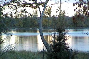
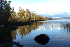 View of Shirleys Bay Dyke
The bay itself and any land other than the dyke is off limits, tempting as it may be to bring in a canoe and explore. Scanning the river side of the dyke can provide a good selection of deeper water birds, including diving ducks, loons and grebes. Uncommon species, such as the three Scoters, Oldsquaw and Red-breasted Merganser, are often seen here. The bay itself will be full of waterfowl during spring and fall movements. Almost anything found in the Ottawa area occurs here. Uncommon waterfowl, such as Northern Shoveler, Gadwall and American Coot, are present in large (for Ottawa) numbers during migrations, especially in autumn. Even scarcer in Ottawa, Redhead, Canvasback and Ruddy Ducks, can sometimes be seen here. Both spring and fall, Barrow's Goldeneye is a possibility among the Common Goldeneye flocks on either side of the dyke. Both Sora and Virginia Rail breed in the marshes, and Least Bittern has and may still. Given the readily available food source, it is not surprising that goodly numbers of raptors patrol the bay. Both Merlin and Peregrine Falcon are seen with some regularity. Snowy Owls and the rare Gyrfalcon are sometimes seen here in mid-April, after the bay opens, fattening up for the trip north. Snowies can also be seen in early winter. And this is one of the best spots around Ottawa to see the locally rare Bald Eagle, which is reported at least once or twice each spring and fall, sometimes perched along the dyke.
As you continue north on the dyke, watch for migrant land birds making their way along it. Watch for a Lapland Longspur hiding in a flock of Snow Buntings or Horned Larks in season. Sometimes shorebirds can be found along the dyke itself. Because of its rocky shore, it is one of the few spots where Purple Sandpipers have been seen in the region. Look for them around the first week of November. Stop and scan the bay frequently, as new vistas open up as you move north. Less common gulls seen here, especially in late fall and early winter, and early spring, include Lesser Black-backed, Thayer's, Glaucous and Iceland. The area just before you reach the first island has deeper water and most diving waterfowl that are inside the dyke will be found here. Common Terns have tried nesting here in the past and post-breeding birds gather here in August. The trail is less used beyond the first island and nearly disappears beyond the second. When you reach the end scan the river around the outlet of Shirleys Bay, still ahead and to the north. The dyke is part of the wastewater treatment scheme, forcing the 'treated' Watts Creek discharge to take the slow route through the bay and eventually come out here, (where it promptly flows downstream to the Britannia Water Filtration Plant and thence into Ottawa's drinking water). This cove, protected by Innis Point to the north, has a good variety of waterfowl, both dabbling and diving. A scan for birds on the water or flying along the main channel of the river could be worthwhile. In late October, small flocks of Red-throated Loons are occasionally seen, almost always as fly-bys.
If it is late in the day when you leave, you may be treated to a spectacle of hundreds of migrant Canada Geese returning to the bay to spend the night. In August and September, you may be alerted to a Black-crowned Night-Heron "quowk"ing on its way to a nighttime perch. If you are really late, you may hear a Great Horned Owl on your way through the woods to the parking lot.
Being one of the best sites around, Shirleys Bay attracts many birders, especially on weekends. If you new to birding or just new to Ottawa, introduce yourself. You may learn something useful. The area has had its share of rarities over the years. Golden Eagle (Oct. 25, 1993, Nov. 3, 1991 & Mar. 19, 1989); Carolina Wren (Oct. 23, 1993); Long-billed Dowitcher (Aug. 8 to 22, 1993); Caspian Tern (Aug. 8 & 15, 1993; 2 - Jun. 25, 2009, up to 17 seen here in August 2010); Great Egret (June 17, 1992; yearly since 2004 in late summer and fall; up to 33 seen here in Aug.-Sep. 2010); Little Gull (Apr. 22, 1992; May 16-21, 2010 - below rapids); Gyrfalcon (Apr. 16 & 18, 1992); Red Phalarope (Oct. 28, 1991); Forster's Tern (Sept. 28, 1991); Northern Hawk Owl (Nov. 11, 1991); Pomarine Jaeger (Oct. 19, 1990); Sandhill Crane (Oct. 8, 1990; 2 - Sep. 20, 2007); Glossy Ibis (May 13, 1990); Buff-breasted Sandpiper (Sept. 12, 1989); Eurasian Wigeon (Oct. 20, 2002); Northern Gannet (Nov. 11, 2002); Forster's Tern (Sep. 18 -20, 2003); Western Sandpiper (July 17, 2005); Parasitic Jaeger (Sep. 17 - 18, 2005); Caspian Tern (3 - Sep. 21, 2005; up to 17 birds, some seen daily through August 2010); Yellow-throated Warbler (Sep. 25, 2005); Marbled Godwit (Sep. 17 to Oct. 6, 2009).
 View of Shirleys Bay Dyke
Ottawa River West: Ontario Route Directions: From Shirleys Bay Dyke parking area (the boat launch), return southward on Rifle (Range) Road 2.0 km to Carling Avenue. Turn right or west and go 2.0 km to the next site Herzberg Road. Turn right or north onto it.
Return to Ottawa River West: Ontario.
Return to Birding Ottawa Table of Contents.
|