Independent Directions to this Site: From Highway 416 take exit 66 (Fallowfield Road). If northbound, the 0.4 km offramp brings you to Fallowfield, where you will turn right or east onto it. If southbound, a 0.4 km offramp dumps onto Fallowfield, where you will turn left or east and in 0.5 km join the northbound offramp traffic. Both groups will now follow Fallowfield Road east for an additional 0.4 km to reach Strandherd Drive. Continue straight east onto Strandherd and follow it 4.4 km to Greenbank Road. Turn right or SSE onto Greenbank and drive 1.5 km SSE to the Jock River bridge. Park just south of the bridge at the Half Moon Bay picnic area to explore the Jock River Conservation Area.
Stony Swamp Loop Route Directions: From the junction of Cambrian & New Cedarview Roads, go ENE on Cambrian for 2.0 km to Greenbank Road. Turn left or NNW onto Greenbank and proceed 0.7 km to the Jock River bridge. Park just south of the bridge at the Half Moon Bay picnic area to explore the Jock River Conservation Area.
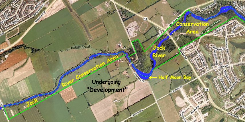
Site Description and Birding Information: If you are a canoe enthusiast, this is a great site for you to explore. The Jock River Conservation Area extends westward, on the south side of the river, all the way to Cedarview Road (2.3 km by canoe). It also extends eastward 1.6 km (by canoe) on both sides of the river, and a further 0.8 km (by canoe) on the south side of the river. From here it is another 1.2 km (by canoe), through Heart's Desire Forest, to the Jock River Landing site at the mouth of the Jock River on the Rideau River.
This conservation area is a very thin buffer zone along the river, being only 100 to 200 metres in the western segment, and up to 400 metres in the eastern part. Subdivisions have now reached it and we'll see if it is sufficient to withstand the population pressure. Regretably, most of the large segment, east of Jockvale Road, is devoted to playing fields. Conservation of nature cannot be goal there. For more information see the Friends of the Jock River site.
 |
 |
Stony Swamp Loop Route Directions: From the Jock River bridge on Greenbank Road travel 3.7 km NNW on Greenbank to Fallowfield Road. Continue across Fallowfield NNW on Greenbank to examine the next site on this loop, the Greenbank Road at Fallowfield area.