Independent Directions to this Site: From Highway 416 take exit 66 (Fallowfield Road). If northbound, the 0.4 km offramp brings you to Fallowfield, where you will turn right or east onto it. If southbound, a 0.4 km offramp dumps onto Fallowfield, where you will turn left or east and in 0.5 km join the northbound offramp traffic. Both groups will now follow Fallowfield Road east for an additional 0.4 km to reach Strandherd Drive. Bear left or north to continue on Fallowfield Road and follow it an additional 3.0 km to Greenbank Road. Turn left or NNW onto Greenbank to examine the Fallowfield & Greenbank Roads area.
Stony Swamp Loop Route Directions: From the Jock River Conservation Area at the Jock River bridge on Greenbank Road travel 3.7 km NNW on Greenbank to Fallowfield Road. Continue across Fallowfield NNW on Greenbank to examine the Greenbank Road at Fallowfield area.
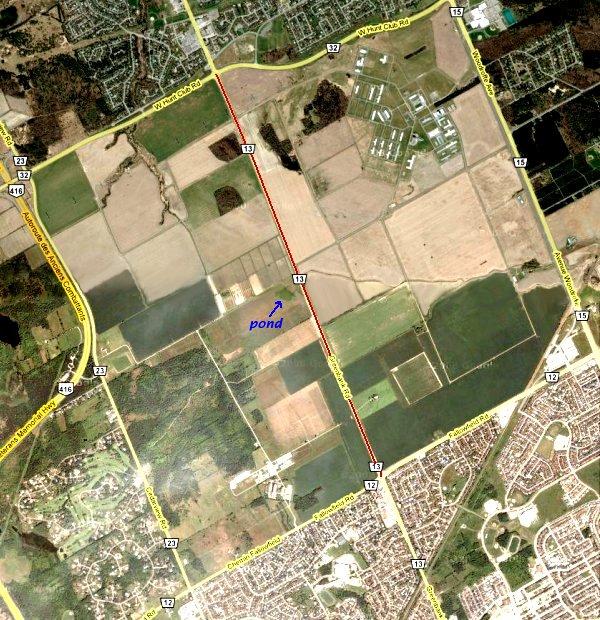
Site Description and Birding Information: The lands to the north of Fallowfield Road, on either side of Greenbank are owned by the Federal Government, mostly Agriculture Canada. The fields here attract many geese during spring and fall, as well as ducks, shorebirds and raptors. Snowy Owls can sometimes be found here in winter. Also watch for flocks of Horned Lark, Snow Bunting and sometimes Lapland Longspur. Gray Partridge have occurred here too.
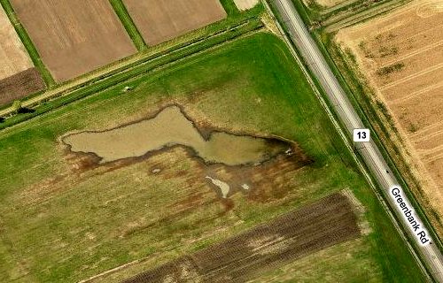
The best way to bird here is from your car, pull off where possible and scan the fields. Traffic can be a problem at certain times, so try to avoid high volume times of day. The roadbed provides a slightly raised platform from which to scope flocks. There is a bike path paralleling the west side of Greenbank from Fallowfield to West Hunt Club Road. Just short of the halfway point to West Hunt Club Road, on the west side of Greenbank, there is a seasonal pond which attracts waterfowl and shorebirds. A Marbled Godwit was seen here on Jun. 9-10, 2011.
It is worth checking the entire 4.1 km of Greenbank NNW to West Hunt Club Road. But since we also want to check the fields to the ENE on the north side of Fallowfield Road and on the west side of Woodroffe Avenue going NNW from Fallowfield, we have restricted this site to the southern half of this 4.1 km stretch of Greenbank. The northern portion is covered by the Greenbank Road at West Hunt Club site.
Stony Swamp Loop Route Directions: From the junction of Fallowfield & Greenbank Roads travel 2.3 km ENE on Fallowfield Road to Woodroffe Avenue. Turn left or NNW onto Woodroffe and go 2.2 km to Slack Road. Turn right or ENE onto Slack and drive 1.5 km to a parking area on the right for the next site on this loop, the Pinhey Forest Reserve: Slack Road area.