REVELSTOKE PARK & AREA
Spring: ** Summer: * Fall: ** Winter: *
Independent Directions to this Site: From Highway 417 (The Queensway) take exit 121A (Bronson Avenue). Go SSE on Bronson for 3.6 km, crossing the Rideau River on the Dunbar Bridge and going over Riverside Drive, before bearing right to take the Brookfield Road exit. In 0.1 km merge right onto Brookfield Road and drive 0.5 km to Riverside Drive. Turn left onto Riverside Drive and go 2.5 km to a segment of the old Riverside Drive on the right or west just before the railway overpass. Turn right or west onto this old roadbed and park at the end of its 0.3 km length.
Rideau River East Side Route Directions: From Mooney's Bay parking area, return to Riverside Drive. Turn right or south on it and proceed 1.9 km to a segment of the old Riverside Drive on the right or west just before the railway overpass. Turn right or west onto this old roadbed and park at the end of its 0.3 km length.
Site Description and Birding Information: From where you are parked a railline blocks access to the south. But it is possible to follow a trail 0.3 km through an overgrown field to the river and make one of several loops to the north to return to your car. Going north along the Rideau at 0.2 km there is a roadway going east up the hill, past a municipal sewer installation (no pond), along powerlines, through scrub, and back to the old Riverside Drive. Turn right on it and go 0.25 km to your car.
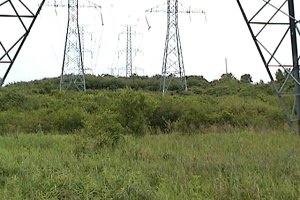 Overgrown Area South of Revelstoke Park
Continuing along the river you will, around the 0.3 km mark, encounter the trials of the smallish Revelstoke Park, an overgrown field and cedar wood area snuggled between Revelstoke Drive and the Rideau River. A trail loops through the park and has an alternate access point at Revelstoke and Leopolds Drives.
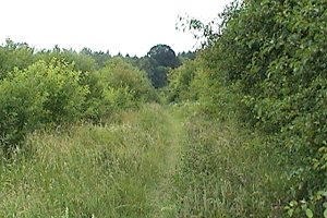 Trail through Revelstoke Park
Rideau River East Side Route Directions: From the parking area near Revelstoke Park, return the 0.3 km to Riverside Drive. Turn right or south on it and proceed 2.4 km to a dirt road on the right or west across from the airport runways. Turn right or west onto this road and park where you are able to pull off the side. This is the next site on this route, Airport Gravel Pit & Cottage Road.
Return to Rideau River East Side.
Return to Birding Ottawa Table of Contents.
|
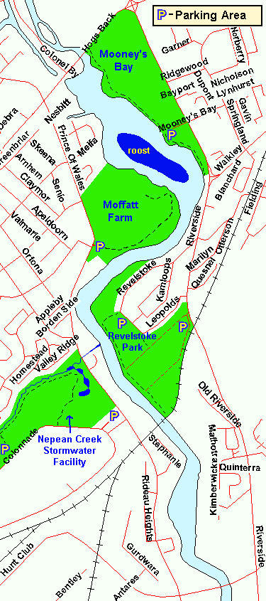 Map of Revelstoke Park & Area
|