Independent Directions to this Site: From where Autoroute l'Outaouais or Highway 50 crosses over Autoroute de la Gatineau or Highway 5, the two major roads converging on Hull, continue on Hwy 50 south 1.3 km to Rue Montcalm. Turn left or southwest on Montcalm and follow it for 0.8 km to Boulevard Alexandre-Taché. Turn right or west on Taché and go 3.6 km to Place Samuel-de-Champlain. Turn left or southeast onto it and drive 0.2 km to Boulevard de Lucerne. Make a righthand turn onto it and go 1.7 km to the NCC's Chaudière parking area on the left. Turn left or southeast into this parking lot near the Chateau Cartier Golf Club (formerly the Chaudière Golf Club).
Ottawa River West: Quebec Route Directions: From the Champlain Park Woods at the east end of McConnell, return west 0.1 km to Chemin Allen and turn left or south onto it. Proceed 0.6 km back to Chemin d'Aylmer and turn left or ENE onto it. Backtrack 1.4 km to Place Samuel-de-Champlain (route to the Champlain Bridge) and turn right or southeast onto it. Drive 0.2 km to Boulevard de Lucerne (aka the Lower Aylmer Road) and make a righthand turn onto it. Go 1.7 km to the NCC's Chaudière parking area on the left. Turn left or southeast into this parking lot near the Chateau Cartier Golf Club (formerly the Chaudière Golf Club).
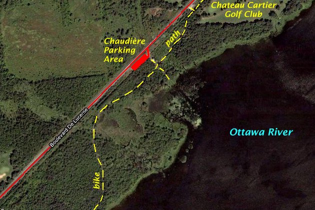
Site Description and Birding Information: The grounds of the golf club are quite wet in spring and sometimes attract waders. The trees along this stretch of road often have Bohemian Waxwings in winter.
The bike path/ski trail continues along the river through this site and is excellent for migrants, especially in spring. Views of the river can net sheltering waterfowl. Green Heron and Yellow-throated Vireo have bred here. The path skirts a wooded swamp just SW of the parking area.
Ottawa River West: Quebec Route Directions: From the Chaudière parking area, turn left or southwest onto Boulevard de Lucerne and drive 1.3 km to a small parking area on the left. Turn left or southeast into this spot and park at our next site on this route Rivermead/Baie Simard.