Independent Directions to this Site: From Boulevard des Allumettières or Highway 148, take the Chemin Eardley exit in Aylmer. Turn right or northwest onto Chemin Eardley or the continuation of Highway 148 and proceed 14.1 km northwest on Eardley to Chemin des Pères Dominicains in Heyworth. Turn left or west onto it. Follow this country road west through farmland 2.0 km to Chemin de la Sapinière. Turn left or south on Sapinière.
Ottawa River West: Quebec Route Directions: From were you are parked at the old rail crossing on Chemin de la Rivière, go north 1.1 km to Chemin des Pères Dominicains. Turn left or west on Pères Dominicains and proceed 1.1 km to Chemin de la Sapinière. Turn left or south onto it.
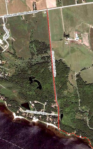
Site Description and Birding Information: This 1.6 km dirt road has a good variety of habitats, beginning in farmland, passing a creek, woodlands, a small marshy pond and deadending at the Ottawa River. Check the flooded fields for waterfowl in spring. Also good for owling in spring; Eastern Screech Owl has nested here. When the main road bends right at 1.4 km onto Chemin des Plages, continue straight 0.2 km to the river. A short walk along the shore to the east brings you to Breckenridge Bay, a good spot for observing waterfowl, loons, grebes and American Coots. Short-eared Owl and Snow Goose have been seen here. On May 3, 2002 a Trumpeter Swan was seen here.
A Great Gray Owl was seen only 1.2 km west of the junction of Chemin des Pères Dominicains and Chemin de la Sapinière on Jan. 9, 2005, during the invasion that winter. Another Great Gray Owl stopped here from Dec. 25, 2008 to at least Jan. 1, 2009.
Ottawa River West: Quebec Route Directions: From the river end of Chemin de la Sapinière, return the 1.6 km to Chemin des Pères Dominicains and turn left or west onto it. Travel 0.5 km on Pères Dominicains to Chemin Papineau. Turn right or north on Papineau and go 1.8 km to Chemin Tremblay. Turn left or west on Tremblay and proceed 2.3 km to Chemin Lamoureux. Turn right or north on Lamoureux and drive 1.6 km to Chemin de la Baie. Turn left or west onto Baie and proceed 1.0 km to Chemin Alary. Turn right or north on Alary and go 2.2 km to Highway 148. Turn left or northwest onto 148 and go 2.9 km to Chemin Parker. Watch carefully for this corner, it is on a righthand curve and requires a sharp left turn. Turn left or south and enter the next site on this route, Chemin Parker.