CHEMIN PARKER
Spring: ** Summer: ** Fall: ** Winter: *
Independent Directions to this Site: From Boulevard des Allumettières or Highway 148, take the Chemin Eardley exit in Aylmer. Turn right or northwest onto Chemin Eardley or the continuation of Highway 148 and proceed 25.1 km northwest on Eardley to Chemin Parker, 1.3 km before reaching the Ramsey Lake (or Eardley-Masham) Road in Eardley. Watch carefully for this corner, it is on a righthand curve and requires a sharp left turn. Turn left or south onto Chemin Parker.
Ottawa River West: Quebec Route Directions: From the river end of Chemin de la Sapinière, return the 1.6 km to Chemin des Dominicains and turn left or west onto it. Travel 0.5 km on Dominicains to Chemin Papineau. Turn right or north on Papineau and go 1.8 km to Chemin Tremblay. Turn left or west on Tremblay and proceed 2.3 km to Chemin Lamoureux. Turn right or north on Lamoureux and drive 1.6 km to Chemin de la Baie. Turn left or west onto Baie and proceed 1.0 km to Chemin Alary. Turn right or north on Alary and go 2.2 km to Highway 148. Turn left or northwest onto 148 and go 2.9 km to Chemin Parker. Watch carefully for this corner, it is on a righthand curve and requires a sharp left turn. Turn left or south onto Chemin Parker.
Site Description and Birding Information: You will pass through a good deal of farmland on the way to this site. Bobolink, Eastern Meadowlark, Savannah Sparrow and Northern Harrier and common in season. Watch for raptors all year.
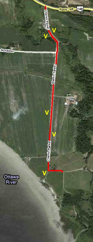
Chemin Parker is a dirt road that has a good variety of habitats, beginning in farmland, passing a gully with woodpecker interest, more farmland and coming out at the Ottawa River in 1.8 km at an overlook giving a wide view of the shore and river. A scope is necessary for best results here. The extensions of the road from this point go to cottages and provide little in the way of interest. Back at the gully, the old rail line provides a inviting hiking trail.
This site is prized as one of the better "public" views of the river for birders. At the end of May all three Scoter species can be seen loafing mid-river, along with other waterfowl. The corn fields have flocks of geese in spring, with Ross' Goose spotted more than once. Horned Larks breed here. In the spring of 2001, a Red-bellied Woodpecker was seen just north of the lookoff.
Ottawa River West: Quebec Route Directions: From the lookoff at the river end of Chemin Parker, return the 1.8 km to Highway 148 and turn left or west onto it. Follow 148 for 1.3 km to the Ramsey Lake Road, a.k.a. Chemin Eardley-Masham. You are now at the next site on this route, Eardley.
Return to Ottawa River West: Quebec.
Return to Birding Ottawa Table of Contents.
|
 Google Satellite Map of Chemin Parker Area
|