FITZROY PROVINCIAL PARK
Spring: *** Summer: *** Fall: ** Winter: **
Independent Directions to this Site: From Highway 417 (The Queensway), take the Antrim exit and drive northeast 0.8 km to Antrim and Highway 17. Turn left or northwest on 17 and go 6.2 km to the Galetta Sideroad. Turn right or northeast onto it and proceed 8.6 km to Regional Road # 5 or Harbour Street. Turn left or northwest toward Fitzroy Harbour here and go 1.9 km through town to Market Street. Turn right on Market and drive southeast 1.1 km to Canon Smith Road. Turn left or northwest and go 1.5 km to the entrance of Fitzroy Provincial Park on the left.
Ottawa River West: Ontario Route Directions: Exit the MacLaren's Landing area from the junction of MacLaren's Side Road and Stonecrest Road. Proceed southeast 0.6 km on Stonecrest Road to Aylwin Road, then turn right or southwest onto Aylwin and go 2.2 km to the Canon Smith Road. Turn right or northwest onto it and proceed 2.6 km to the entrance of Fitzroy Provincial Park on the left.
 Map of Fitzroy Provincial Park
Site Description and Birding Information: This very popular provincial park is crowded all summer and has a fee for day use. The West Carleton Nordic Ski Club maintains several kilometres of cross-country ski trails and have a clubhouse in the park. The trails are open daily, the clubhouse on weekends only. Non-members are asked only to sign a register before trying the trails.
That being said, it has a wonderful variety of habitat and two major trails to explore. The Terraces Trail (2.0 km - interpretive) explores the variety of geological formations exposed along the cliffs and bluffs formed by ancient river channels. While the Carp Trail (2.2 km) meanders through young forests and along the banks of the Carp River.
Red-shouldered Hawk has been seen here in breeding season.
Contact the park at 613-623-5159 for further information.
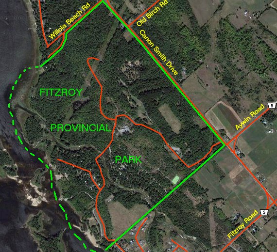 Google Satellite View of Fitzroy Provincial Park Area
Ottawa River West: Ontario Route Directions: From the entrance of Fitzroy Provincial Park, turn right or southeast and drive 2.0 km to Market Street, Fitzroy Harbour. Turn right or southwest onto it and proceed 1.1 km to Harbour Street. Turn left or southeast onto Harbour and go 0.5 km to Victoria Street. Turn right or southwest onto it and follow it as it curves round to the northwest to the entrance to Chats Dam. The entrance is on the right and normally gated off. However, directly across the turnabout is a dirt road that leads to the base of Chats Dam, our next site.
Return to Ottawa River West: Ontario.
Return to Birding Ottawa Table of Contents.
|