RIFLE (RANGE) ROAD
Spring: ** Summer: * Fall: *** Winter: **
Independent Directions to this Site: From Highway 417 (The Queensway) take exit 134 (Moodie Drive). If travelling west, the 0.4 km offramp dumps you right or north onto Moodie. If driving east, a 0.3 km offramp brings you to Moodie Drive, where you will turn left or north onto it and in 0.5 km join the westbound offramp traffic. Both groups will now follow Moodie Drive north 1.3 km from here to Carling Avenue. Turn left or northwest on Carling and go 2.2 km to Rifle (Range) Road. Turn right or north onto Rifle Road.
Ottawa River West: Ontario Route Directions: From the Watts Creek Trails, return 0.5 km north on the southern extension of Rifle Road to Carling Avenue. Cross Carling and join Rifle (Range) Road.
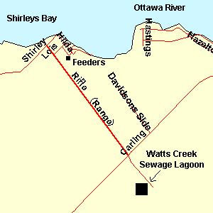 Map of Rifle (Range) Road
Site Description and Birding Information: This road leads to one of the best birding spots in the Ottawa area, Shirleys Bay Dyke. But it is often overlooked for its own potential. Raptors are easily seen here. There is a huge Osprey nest on one of the big electrical pylons on the west side about half way to the boat launch. In late fall flocks of sparrows are found in the weeds and scrub along the road, especially the northern section; some winter. Northern Shrike and Bohemian Waxwing are found here in winter as well as a resident albino Red-tailed Hawk, which is sometimes reported as a Gyrfalcon. In the 2004 - 05 invasion, a Great Gray Owl was found along Rifle Road, between Lois and Carling Avenues from Jan. 1 to at least Mar. 6, 2005. Two were seen from Jan. 15 - 24, 2005.
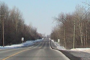 Rifle (Range) Road Looking North
|
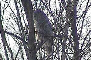 Great Gray Owl along Rifle Road - Feb. 5, 2005
|
Ottawa River West: Ontario Route Directions: From the boat launch parking area at the north end of Rifle (Range) Road on Shirley's Bay, return 0.3 km south on Rifle Road to Lois Avenue. Turn left or east and enter the next site, Shirleys Bay Cottage Area. You may wish to leave your vehicle at the boat launch and do this site and the Shirleys Bay Dyke on foot.
Return to Ottawa River West: Ontario.
Return to Birding Ottawa Table of Contents.
|