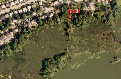
Independent Directions to this Site: Going north on Autoroute de la Gatineau or Highway 5 take Exit # 2, the Autoroute 50 east exit. Follow the long, 1.0 km, ramp over Brewery Creek and onto Autoroute 50 headed north. Proceed 13.8 km to exit 150, taking the Boulevard Lorrain exit southeast. Follow the 0.7 km exit to Lorrain and turn right or south onto it. Go 2.5 km south to Boulevard Maloney Est and turn left or east on it. Proceed 0.9 km east to Rue des Sables. Turn right or south on des Sables and go 0.2 km to Rue Notre-Dame. Turn left or east on Notre-Dame and proceed about 0.4 km to an old road, now only a trail, leading off to the right or south opposite 1105 Notre-Dame. If you reach Rue Bigras, you have gone a bit too far. This is the access for the marshes at Baie McLaurin. There is a pulloff here where you can park.
Ottawa River East: Quebec Route Directions: From the parking area at Parc du Lac Beauchamp, return south to Boulevard Maloney Est and turn left or east on it. Follow Maloney east for 2.5 km to Rue des Sables. Turn right or south on des Sables and go 0.2 km to Rue Notre-Dame. Turn left or east on Notre-Dame and proceed about 0.4 km to an old road, now only a trail, leading off to the right or south opposite 1105 Notre-Dame. If you reach Rue Bigras, you have gone a bit too far. This is the access for the marshes at Baie McLaurin. There is a pulloff here where you can park.
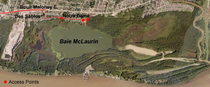
Site Description and Birding Information: The trail extends into the marshes (depending on the water levels) of the bay and provides excellent views of a variety of good wetland habitat. Notable among breeding birds here is a small colony of Black Terns.
There is another access about 0.45 km east on Notre-Dame at the Parc des Pêcheurs. A trail from here goes to the shore also. 1.5 km beyond that is the access road for the boat launch. Of course, this road extends to the shore. From here you could launch a canoe and explore the farther reaches and backwaters of the marsh. A Caspian Tern was seen here on Jun. 25, 2010.
Ottawa River East: Quebec Route Directions: From the trailhead at Baie McLaurin, follow Rue Notre-Dame east c. 0.6 km to Avenue du Cheval-Blanc. Turn left or north on it and go 0.1 km to Boulevard Maloney Est. Turn right or east on it and drive 1.9 km to Boulevard de l'Aéroport. Turn left or north onto it and proceed 1.2 km to Chemin Industriel and the starting point for coverage of the next site on this route, the Gatineau Airport (officially "Aéroport exécutif de Gatineau-Ottawa").