Independent Directions to this Site: Going north on Autoroute de la Gatineau or Highway 5 take Exit # 2, the Autoroute 50 east exit. Follow the long, 1.0 km, ramp over Brewery Creek and onto Autoroute 50 headed north. Proceed 17.8 km to exit 154, taking the Boulevard de l'Aéroport exit. Follow the 0.3 km exit to it and turn left or north. Go 0.3 km north to Chemin Industriel and the starting point for coverage of the Gatineau Airport (officially "Aéroport exécutif de Gatineau-Ottawa").
Ottawa River East: Quebec Route Directions: From the trailhead at Baie McLaurin, follow Rue Notre-Dame east c. 0.6 km to Avenue du Cheval-Blanc. Turn left or north on it and go 0.1 km to Boulevard Maloney Est. Turn right or east on it and drive 1.9 km to Boulevard de l'Aéroport. Turn left or north onto it and proceed 1.2 km to Chemin Industriel and the starting point for coverage of the Gatineau Airport (officially "Aéroport exécutif de Gatineau-Ottawa").
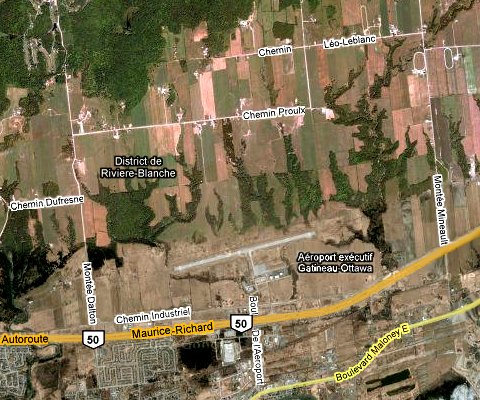
Site Description and Birding Information: Like many airports this one can be interesting for field birds and raptors. Snowy Owls and Northern Shrikes have wintered here. Short-eared Owls have been seen here as well. A dark phase Red-tailed Hawk, very rare here, wintered here in 2004 - 2005. In the invasion winter of 2004 - 2005, several Great Gray Owls favoured this area. The roads surrounding the Gatineau Airport (Industriel, Dalton, Dufresne and Myre) hosted up to 7 Great Grays from Jan. 22 to at least Mar. 25, 2005. One Great Gray Owl was found on Montée Dalton on Feb. 22-23, 2006.
Birding the airport area is best done by skirting the perimeter using Chemin Industriel and Montée Dalton (was Montée McLaren). Be sure to range wider afield, say on Dalton, Dufresne, Myre, etc., searching for interesting raptors.
Also watch for Upland Sandpipers east of the airport along Autoroute 50.
Ottawa River East: Quebec Route Directions: From the junction of Boulevard de l'Aéroport and Chemin Industriel, at the airport entrance, return 1.2 km south on Boulevard de l'Aéroport to Boulevard Maloney Est or Highway 148. Turn left or ENE onto it and drive 2.0 km toward Angers. Turn right or south on a single lane gravel road between numbers 1974 and 1976 Boulevard Maloney Est. This is the next site on this route, called Marais des Laîches West.