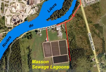
MASSON SEWAGE LAGOONS
Spring: ** Summer: ** Fall: ** Winter: *
Independent Directions to this Site: Going north on Autoroute de la Gatineau or Highway 5 take Exit # 2, the Autoroute 50 east exit. Follow the long, 1.0 km, ramp over Brewery Creek and onto Autoroute 50 headed north. Proceed 30 km to exit 166 (the final exit on 50 at this time), following the exit ramp 0.6 km as it loops back around to Rue Notre-Dame. Turn left or south and go 0.6 km SSE to where Chemin de Montréal or Highway 148 join Notre-Dame. Continue straight SSE 0.2 km to where Chemin de la Quai splits off to the right. Bear right or southeast on Chemin de la Quai and go 0.6 km to Chemin de la Pointe. Turn right or southwest on Chemin de la Pointe and drive about 1.5 km down this dirt road to the turnoff on the left or southwest to the Masson Sewage Lagoons.
Ottawa River East: Quebec Route Directions: From the public access for Baie Clément, turn right or ENE on Chemin de Montréal Ouest or Highway 148 and go 3.8 km to the 3-prong junction at Masson. Bear right or southwest on Notre-Dame and Montréal Ouest, still 148, following this for 0.3 km to where Montréal and Chemin de la Quai split. Turn right or southeast on Quai and go 0.6 km to Chemin de la Pointe. Turn right or southwest on Pointe and drive about 1.5 km down this dirt road to the turnoff on the left or southwest to the Masson Sewage Lagoons.
 MS Virtual Earth Satellite Map of Masson Sewage Lagoons
Site Description and Birding Information: Chemin de la Pointe runs along the mouth of the Rivière du Lièvre. Unfortunately, the end of the road is gated. The old willows along the river could be worth checking in migration. The sewage lagoons are on the east side of the road and the entry road allows one to drive up onto the berm where one pond can be scanned from the car. The second pond can be scoped from the fence, as can a bit of a third. But a fourth pond cannot be seen from here. Watch for waterfowl, gulls and shorebirds during migration, and waterfowl and gulls in winter.
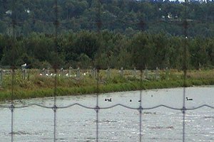 View of Masson Sewage Lagoons
About 0.5 km east of the road into the lagoons is a dirt road running down the east side of the ponds. This road runs past some deciduous woodland to the east and eventually goes around behind the third and least viewable pond. This road should be good for migrant land birds and, with patience, shorebirds and waterfowl coming or going from the lagoons. A scalable five-foot fence blocks access to the sloping twenty-foot high berm.
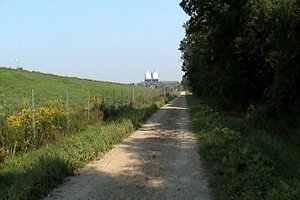 View of Road on East Side of Masson Sewage Lagoons
Good birds seen here include: Redhead (2 - April 30, 2005).
Ottawa River East: Quebec Route Directions: From the Masson Sewage Lagoons, return northeast on Chemin de la Pointe 1.5 km to Chemin de la Quai. Turn right or southeast onto it and proceed 1.2 km to the Masson-Angers municipal dock, from which the Masson-Cumberland ferry leaves every few minutes to cross the Ottawa River ($6.00). Park near here for access to the next site on this route, the marshes near the Masson Ferry Dock.
Return to Ottawa River East: Quebec.
Return to Birding Ottawa Table of Contents.
|