BEECHWOOD CEMETERY and JOHN MACOUN MARSH
Spring: ** Summer: ** Fall: ** Winter: *
Independent Directions to this Site: From Highway 417 (The Queensway) take exit 117 (Vanier Parkway). Go northwest 3.0 km to Beechwood Avenue and turn right or northeast on it. Proceed 1.1 km to the entrance, on the right or SW side, to the Beechwood Cemetery.
Ottawa River West: Ontario Route Directions: From the parking spot across from Acacia Avenue on Hillsdale Road at Rockcliffe Park East, proceed south on Acacia Avenue for 1.2 km to Montrose Avenue. Turn left or east on Montrose and drive 0.2 km to Juliana Road. Turn right or southeast on it and go 0.1 km to Beechwood Avenue. Cross Beechwood Avenue into the western entrance of the Beechwood Cemetery.
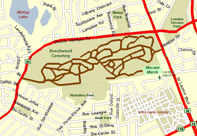 Map of Beechwood Cemetery and John Macoun Marsh
Site Description and Birding Information: This beautifully maintained cemetery has lots of birding potential. Over the years many interesting species have been seen here, especially in spring migration. The park-like grounds have many venerable old trees, lots of shrubs and flower beds. There are a multitude of paved loops through the established portions of the graveyard. There are many beautiful spots where one can contemplate both death and life. By following the central southerly loop you will find yourself adjacent the Richilieu Vanier Park, a small stand of sugar maples and urban sugar bush. There is a fence all around the cemetery, but if you are on foot you may find an impromptu "entrance" here maintained by locals intent on a shortcut.
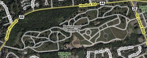 Google Satellite Map of Beechwood Cemetery and John Macoun Marsh
The southeastern corner which was wooded has succumbed to population pressure and is now "under development". However, the marsh in that area has been adopted by the students of Educarium School as a research project, under the tutelage of teacher Mike Leveille. Their interest and diligence has saved this bit of urban wilderness from certain demise. Beechwood Cemetery is helping the class protect this tiny gem. The marsh will henceforth be known as the John Macoun Marsh. The students are documenting species found here and have over 700 to date, 70 of those being birds. The class has maintained a feeding station here since the winter of 2003 - 04, with around 15 feeders during the 2004 - 05 season.
The Beechwood Cemetery and the Macoun Marsh Sub-committee will unveil the landscaping plan on May 31, 2005. Come here to celebrate this achievement, when a plaque will be erected at the marsh.
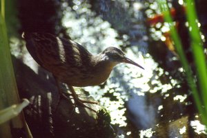 Virginia Rail at the John Macoun Marsh - Photo courtesy Mike Leveille
One of Ottawa's invading Great Gray Owls visited Manor Park, just the other side of Hemlock Road from here, on Jan. 2, 2005.
Ottawa River West: Ontario Route Directions: From the western entrance of Beechwood Cemetery, turn right or northeast onto Hemlock Road, the eastern extention of Beechwood Avenue. Go 3.0 km northeast, then east, on Hemlock. You will cross St. Laurent Boulevard and pass under the Aviation Parkway. At 3.0 km turn left or north on Polaris Avenue, entering the grounds of our next site on this route, the Former CFB Rockcliffe.
Return to Ottawa River East: Ontario.
Return to Birding Ottawa Table of Contents.
|