GAGNON TRAIL SOUTH OF CLARENCE-CAMBRIDGE BOUNDARY ROAD
Spring: ** Summer: *** Fall: ** Winter: ***
Independent Directions to this Site: From Highway 417, 39 km east of Ottawa, take the Limoges exit (79) and go NNW for 4.4 km on Limoges Road (CR 5), through the town of Limoges to the junction of this road with Regional Roads 8 and 37. Follow the right hand curve on Regional 37 or the Saumure/Clarence-Cambridge Boundary Road northeast for 0.9 km to where Saumure turns left. Then continue straight northeast on the Clarence-Cambridge Boundary Road for an additional 4.9 km to the Gagnon Trail South of Clarence-Cambridge Boundary Road. Turn right or SSE to enter the trail.
Larose Forest Loop Route Directions: From wherever you are on Drouin Road North of Clarence-Cambridge Boundary Road, return SSE on Drouin Road to the Clarence-Cambridge Boundary Road. Turn left or northeast on it and go 1.2 km to the Gagnon Trail South of Clarence-Cambridge Boundary Road. Turn right or SSE to enter the trail.
 Map of the Gagnon Trail South of Clarence-Cambridge Boundary Road Area
Click on other site numbers to go to their pages.
Map of the Gagnon Trail South of Clarence-Cambridge Boundary Road Area
Click on other site numbers to go to their pages.
Site Description and Birding Information: Gagnon Trail South of Clarence-Cambridge Boundary Road is a dirt track giving access to the forested area in the southwestern portion of the Larose Forest. It is possible that this track could be driven, with caution and a 4-wheel drive vehicle, during drier times of year; but it is obvious that it would be better to bird this "trail" on foot. There is a good mix of deciduous and coniferous forest with scattered wooded swamplands along the way.
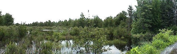 Marsh along Gagnon Trail
About 1.2 km from the Clarence-Cambridge Boundary Road, the trail dekes left or east; then after 0.8 km it meets another old trail. Turn right or south again for another 0.5 km and turn right or west. Here, you could also go another 0.2 km to the old Route 100W track and turn right or west. Both routes meet on Route 100 in about 1.7 km to the west. From there the trail cross Route 100W and generally trends 1.2 km, where it turns SSE and comes out onto Route 200W in 1.0 km. By continuing west on Route 100W, where the trail crosses, for 1.6 km Grant Road can be reached. A walking loop back to the beginning of the Gagnon Trail at the Clarence-Cambridge Boundary Road could be done by going north on Grant Road 1.8 km to the Clarence-Cambridge Boundary Road, and then going east for 2.5 km on the Clarence-Cambridge Boundary Road to Gagnon Trail. The entire loop would be 8.5 km. The area can be quite wet in any season but winter, so boots are recommended in warmer months. Insects can be bothersome at that time too. As well as being good for birding, especially in migration, this trail is excellent all summer for butterflies and dragonflies.
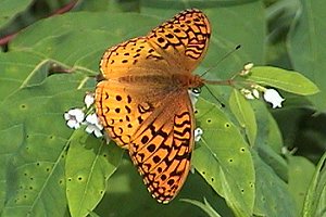 Fritillary on Milkweed
|
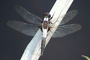 Chalk-fronted Corporal
|
Gagnon Trail - June 24, 2005
Larose Forest Loop Directions: From the Gagnon Trail at Clarence-Cambridge Boundary Road, go east on the Clarence-Cambridge Boundary Road for 0.5 km to Fisher Road. Turn left or NNW into the next site on this route, Fisher Road North of Clarence-Cambridge Boundary Road.
Return to Larose Forest Loop.
Return to Birding Ottawa Table of Contents.
|