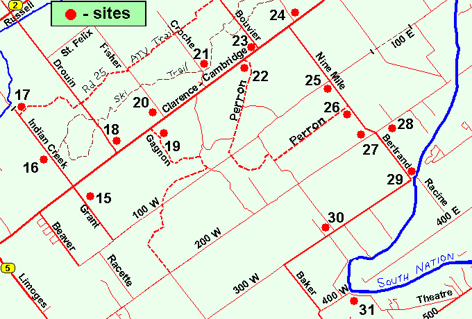
PINEVIEW PICNIC AREA
Spring: ** Summer: *** Fall: ** Winter: ***
Independent Directions to this Site: From Highway 417, 39 km east of Ottawa, take the Limoges exit (79) and go NNW for 4.4 km on Limoges Road (CR 5), through the town of Limoges to the junction of this road with Regional Roads 8 and 37. Follow the right hand curve on Regional 37 or the Saumure/Clarence-Cambridge Boundary Road northeast for 0.9 km to where Saumure turns left. Then continue straight northeast on the Clarence-Cambridge Boundary Road for an additional 2.3 km to Indian Creek (left) and Grant (right) Roads. Turn left or NNW onto Indian Creek and go 1.0 km to the Pineview Picnic Area. Parking on left.
Larose Forest Loop Route Directions: From the Grant Road South of Clarence-Cambridge Boundary Road area, return to the junction of Clarence-Cambridge Boundary and Grant Roads and continue straight or NNW on what is now Indian Creek Road for 1.0 km to the Pineview Picnic Area. Parking on left.
 Map of the Pineview Picnic Area
Click on other site numbers to go to their pages.
Map of the Pineview Picnic Area
Click on other site numbers to go to their pages.
Site Description and Birding Information: Indian Creek Road, sometimes labelled "11", passes through a good variety of habitat on its way to the barricade above Indian Creek, including some stands of mature pine and a small woodland pond. One kilometre in is the Pineview Picnic Area which has used to be a large picnic site, but now has just one table. It is still good for birding though. The shelter is gone but the large parking area remains as a terminus for the cross-country ski trails which run over 10 km to the ENE. A ATV trail also runs west from the parking area. One of the attractions here is the large stand of mature pines. Blue-headed Vireo has been seen here in summer.
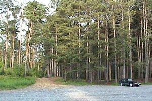 Pineview Picnic Area
There are several wood roads/trails leading off in both directions along the length of Indian Creek Road. One of these, a third of a kilometre NNW beyond the picnic area is the JGL Logging Road on the left or SSW. On the right of this corner (to the NNE) is a woodland pond. An Olive-sided Flycatcher spent at least a week in early June 2008 around the pond at the junction of Indian Creek and JGL Logging Roads.
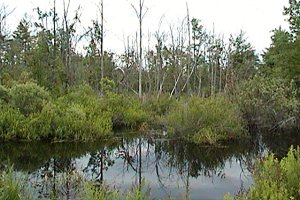 Woodland Pond at Indian Creek and JGL Logging Roads
Larose Forest Loop Directions: From the Pineview Picnic Area, continue straight or NNW on Indian Creek Road for a further 1.6 km to the barracade at the next site on this route, the Indian Creek Road North End.
Return to Larose Forest Loop.
Return to Birding Ottawa Table of Contents.
|