BEAR BROOK at FRANK KENNY ROAD
Spring: *** Summer: ** Fall: ** Winter: *
Independent Directions to this Site: From Highway 417 (The Queensway) take exit 96 (Boundary Road). Proceed 2.0 km NNW on Boundary Road to Russell Road (Regional 26). Turn right or ESE onto Russell and drive 6.5 km to Frank Kenny Road. Turn left or NNW on Frank Kenny and go c. 3.0 km to Bear Brook.
Spring Flooding Route Route Directions: From the south end of Trim Road at the Bear Brook at Trim Road site, return NNW the c. 0.5 km to Perrault Road. Continue straight on Trim for an additional 0.3 km to McFadden Road. Turn right or ENE on McFadden and drive 1.4 km to Frank Kenny Road. Turn right or SSE on it. Proceed 0.5 km to Bear Brook.
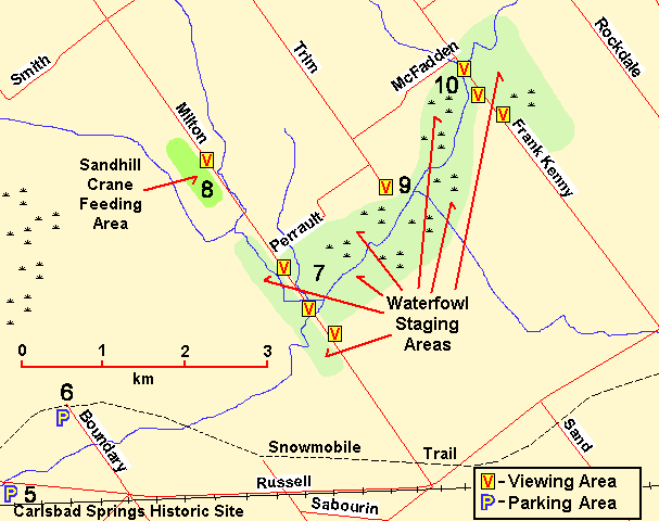 Map of Bear Brook at Frank Kenny Road area
Site Description and Birding Information: This is the third spot from which to view the floodplain of Bear Brook. After having studied the spring waterfowl from the Bear Brook at Milton Road site, and perhaps also from the Bear Brook at Trim Road site, this is another area worth checking. Lighting conditions are good here in the morning on sunny days on the west side of Frank Kenny, and in afternoons on the east side. There is usually some deeper water on the west side, especially toward the back and in the creek channel where there are often diving ducks, especially Ring-necked Duck. Wood Ducks can usually be found along the edge of the woods to the west. The east side has several flooded areas in the spring as well as many fields of corn stubble favoured by the feeding geese and ducks. Here there are large gatherings of Canada Goose in spring. Scan these flocks for the much less common Snow Goose and Greater White-froned Goose, both of which have been seen here. A Ross's Goose was seen here April 20, 2008.
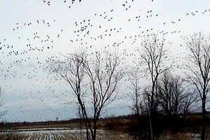 A Sky Full of Geese - Bear Brook at Frank Kenny Road
|
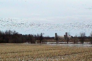 Looking East - Bear Brook at Frank Kenny Road
|
Patrolling raptors, especially Northern Harriers, are often seen. Eastern Phoebe and Eastern Bluebird are sometimes found along Frank Kenny Road between Bear Brook and Russell Road at the same time of year as the waterfowl.
This is also the ninth site on the Mer Bleue - French Hill Loop.
Spring Flooding Route Route Directions: From Bear Brook at Frank Kenny Road, go SSE 3.0 km to Russell Road. Turn left or ENE on it and drive 19.1 km to Champlain Road (Regional 8) in Bourget. Turn left or NNW on it and proceed 6.2 km to St. Pascal Road. Turn right or ENE onto St. Pascal Road and go 1.4 km to Pilon Road. Turn right or SSE on Pilon and drive 0.3 km to the deadend and the next site on this loop, Cobbs Lake Creek at Pilon Road.
Return to Spring Flooding Route.
Return to Birding Ottawa Table of Contents.
|