WATSON'S MILL
Spring: ** Summer: * Fall: ** Winter: **
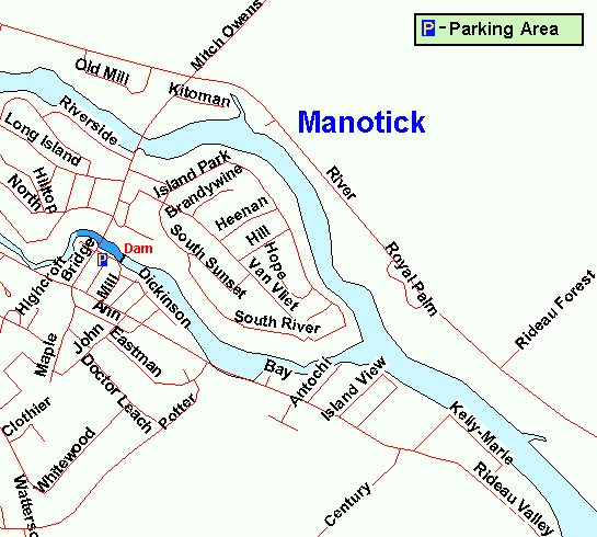
Independent Directions to this Site: From Highway 416 (The Veteran's Memorial Highway) take exit 57 (Bankfield Road) and turn northeast on it. Follow Bankfield 4.0 km northeast to Rideau Valley Drive/Main Street, then turn right or southeast onto Main Street. Go 0.3 km to Bridge Street and turn left or ENE onto it. Drive 0.2 km to Dickinson Street and turn right or southeast onto it. There is parking near the old mill on the right for the Watson's Mill site in Manotick.
Rideau River West Side Route Directions: From the parking area for Beryl Gaffney Park, return to Rideau Valley Drive and turn left or southeast onto it. Go 2.9 km to Bridge Street and turn left or ENE onto it. Drive 0.2 km to Dickinson Street and turn right or southeast onto it. There is parking near the old mill on the right for the Watson's Mill site in Manotick.
 Map of Watson's Mill Area
Site Description and Birding Information: The Rideau River, West Branch, that flows on the west side of Long Island, especially near Bridge Street, just below Watson's Mill in Manotick, is excellent in winter for large flocks of Mallard, a few Black Duck and Common Merganser, and occasionally something more interesting such as a Wood Duck. As the river freezes each winter, the ducks concentrate more and more near the bridge, where the water stays open and the locals feed them. The Old Mill is an interesting landmark and Dickinson Square Conservation Area is found just above the dam by the mill.
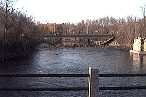 View of Watson's Mill Area
Rideau River West Side Route Directions: From the parking area at Watson's Mill, return the 100 metres or so on Dickinson Street to Bridge Street and turn left or southwest onto it. Drive 0.2 km to Main Street and turn left or southeast onto it. Proceed 7.0 km to Upton Road and turn left or northeast into it. Go 0.2 km northeast to Clingin Lane and turn left or north onto it. Proceed 0.5 km to the end of Clingin Lane at its junction with Aston. Park here to visit the next location along this route, the Hickman Conservation Area.
Return to Rideau River West Side.
Return to Birding Ottawa Table of Contents.
|