BERYL GAFFNEY PARK
Spring: ** Summer: ** Fall: ** Winter: **
Independent Directions to this Site: From Highway 416 (The Veteran's Memorial Highway) take exit 66 (Fallowfield Road). Northbound traffic exit right, take the 0.4 km offramp to Fallowfield Road, then turn right or NNE. Southbound traffic exit right, take the 0.4 km offramp to Fallowfield Road, then turn left or NNE onto it and in 0.5 km join the northbound traffic. Both groups will now follow Fallowfield Road east for an additional 0.4 km to reach Strandherd Drive. Continue straight east onto Strandherd and follow it 6.7 km to Woodroffe Avenue. Turn right or SSE onto Woodroffe and drive 2.1 km to Prince of Wales Drive (Prescott Highway). Turn right or south onto it and proceed 1.9 km to Rideau Valley Drive/Jockvale Road, then turn left or southeast onto Rideau Valley Drive. Go 0.2 km to the entrance, on the left or northeast, of the parking area for the Beryl Gaffney Park.
Rideau River West Side Route Directions: From the parking area for Jock River Landing, turn left or south onto Prince of Wales Drive (Prescott Highway). Proceed 1.4 km to Rideau Valley Drive/Jockvale Road, then turn left or southeast onto Rideau Valley Drive. Go 0.2 km to the entrance, on the left or northeast, of the parking area for the Beryl Gaffney Park.
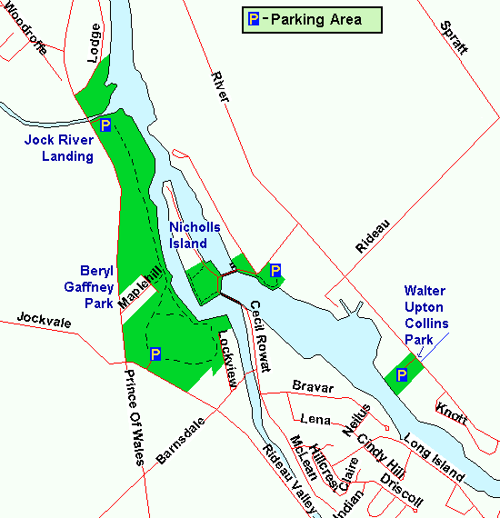 Map of the Beryl Gaffney Park area
Site Description and Birding Information: The former Maple Hill Park has been renamed Beryl Gaffney Park and is being groomed for heavier use. This is a gem of a site, with several trails, some of which lead to the adjacent Jock River Landing location. These trails run along and sometimes cross the drainage gullies leading to the Rideau River. Portions of the trail system run along the Rideau, providing good views of the river and of Nicolls Island to the east. To the north the trail comes out on, follows, and continues beyond the deadend Hazelwood Way, which has good feeders in the winter season.
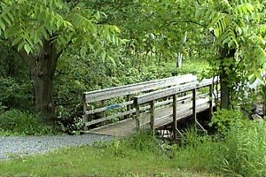 Trail at Beryl Gaffney Park
|
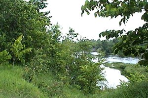 Rideau River at Beryl Gaffney Park
|
Rideau River West Side Route Directions: From the parking area for Beryl Gaffney Park, return to Rideau Valley Drive and turn left or southeast onto it. Go 2.9 km to Bridge Street and turn left or ENE onto it. Drive 0.2 km to Dickenson Street and turn right or south onto it. There is parking near the old mill on the right for the next location along this route, the Watson's Mill in Manotick.
Return to Rideau River West Side.
Return to Birding Ottawa Table of Contents.
|