CHAPMAN MILLS CONSERVATION AREA
Spring: ** Summer: ** Fall: ** Winter: *
Independent Directions to this Site: From Highway 416 (The Veteran's Memorial Highway) take exit 66 (Fallowfield Road). Northbound traffic exit right, take the 0.4 km offramp to Fallowfield Road, then turn right or NNE. Southbound traffic exit right, take the 0.4 km offramp to Fallowfield Road, then turn left or NNE onto it and in 0.5 km join the northbound traffic. Both groups will now follow Fallowfield Road east for an additional 0.4 km to reach Strandherd Drive. Continue straight east onto Strandherd and follow it 6.7 km to Woodroffe Avenue. Turn right or SSE onto Woodroffe and drive 2.1 km to Prince of Wales Drive (Prescott Highway). Turn left or north onto it and go 1.9 km to Winding Way. Turn right or NNE into it and immediately after entering Winding Way turn right into the parking lot for the Chapman Mills Conservation Area.
Rideau River West Side Route Directions: From the Clarke Bellinger Environmental Facility area, return along Leikin Drive 0.7 km to Beckstead Road and turn right or northeast onto it. Go 0.2 km northeast to Merivale Road and turn right or SSW onto it. Drive 0.3 km to Prince of Wales Drive and turn right or south onto it. Proceed 1.8 km to Winding Way and turn left into it. Immediately after entering Winding Way turn right into the parking lot for the Chapman Mills Conservation Area.
Site Description and Birding Information: This 1.2 km sliver of marsh between Winding Way and Lodge Road, is the newly minted (2000) Chapman Mills Conservation Area. A newly built trail and boardwalk extends the length of this strip, though the last 100 metres to Lodge Road seems less offical. Apparently not usable by the developers except as a trading chip.
However it came to be, it is a beautiful walk any time of year. But best for birding when the marsh is alive. The trail leads through the marsh, along river mud flats and, toward the Lodge Road end, through some scrub that could attract migrants. There is a bridge over a small creek which is removed for the winter, but as long as the mud is frozen one can walk across and rejoin the boardwalk.
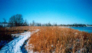 Marsh Boardwalk in Winter
|
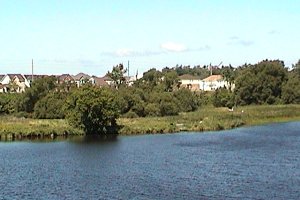 Summer Marsh from across the Rideau
|
Rideau River West Side Route Directions: From the Chapman Mills Conservation Area, return to Winding Way and turn left or SSW onto it. Turn immediately left or south onto Prince of Wales Drive (Prescott Highway) and drive 1.2 km to Lodge Road. Turn left or south onto it to enter the next location along this route, Lodge Road.
Return to Rideau River West Side.
Return to Birding Ottawa Table of Contents.
|
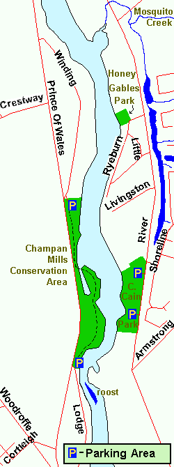 Map of Chapman Mills Conservation Area
|