NICHOLLS ISLAND
Spring: ** Summer: * Fall: ** Winter: **
Independent Directions to this Site: From Highway 417 (The Queensway) take exit 121A (Bronson Avenue). Go SSE on Bronson for 3.6 km, crossing the Rideau River on the Dunbar Bridge and going over Riverside Drive, before bearing right to take the Brookfield Road exit. In 0.1 km merge right onto Brookfield Road and drive 0.5 km to Riverside Drive. Turn left onto Riverside Drive and go 6.0 km to where it becomes River Road. Then continue straight or south along River for an additional 7.8 km to the turnoff, on the left or south, for Nicholls Island Road. Turn right or west onto it and go 0.3 km to the parking area, on the left or south, for the Rideau Canal National Historic Site (Long Island Locks) and Nicholls Island.
Rideau River East Side Route Directions: From the Claudette Cain Park return to River Road and turn right or south on it. Proceed 2.3 km to Nicholls Island Road and turn right or west onto it. Go 0.3 km to the parking area, on the left or south, for the Rideau Canal National Historic Site (Long Island Locks) and Nicholls Island.
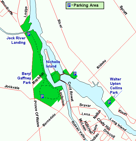 Map of the Nicholls Island area
Site Description and Birding Information: The parking area mentioned above is pay parking, at least in tourist season. If you take the road on the right just beyond the parking lot, there is a small parking area at the park headquarters 100 m from the corner. Another option is to drive across to Nicholls Island, but expect a "locals only" rule to be enforced in high season. It is better to walk anyway.
This site is part of the Rideau Canal National Historic Site (the Northern Sector Depot or Long Island Locks). The grounds on the east side of the locks have many beautiful old deciduous trees. A trail leading south, then east back to the parking lot, has willows, scrub and marshy areas. From the locks and connected dam, there are excellent views of the river below, where there are often a few ducks.
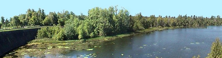 View of the Southeast End of Nicholls Island
Crossing the footbridge over the locks, then the dam itself, gives you access to Nicholls Island. The southern end of this 800 by 150 metre island is owned by Parks Canada as part of the National Historic Site. Thus it has avoided much of the development seen elsewhere along the river. North of the two dams and tiny picnic area, there is forest and scrub habitat. A trail circles around the southern portion of the island, with the road along the east shore being the eastern leg of the loop. Excellent variety of habitat. Great migrant potential.
The view below the second dam is great, with waterfowl and gulls roosting on the rocks. There are fishermen's trails down to the water. The walkway across this dam leads to Cecil Rowat Lane on Long Island, but is gated and signed "Private Property". That seems odd for a street, and the well-beaten path over the fence suggests it is generally ignored; or applies to the land other than the street. Maybe it's another "locals only" matter.
Rideau River East Side Route Directions: From the Nicholls Island parking area return to Nicholls Island Road and turn right or east and proceed 0.3 km to River Road. Turn right or south on it and drive 1.1 km to the turnoff, on the right or west, for the next site on this route, Walter Upton Collins Park.
Return to Rideau River East Side.
Return to Birding Ottawa Table of Contents.
|